
Kuwae (also called Karua) is a submarine stratovolcano with a summit caldera. Kuwae has erupted at least 12 times since 1452 with the most recent eruption in 1974. Eruptions were reported in 1977, 1979, and 1980 but not confirmed. Most of these eruptions were small to moderate (VE1=0-2). The 1897-1901 eruption built an island 0.6 mile (1 km) long and 50 feet (15 m) high. The island eroded away in the following six months. The 1948-1949 eruptions also built a cone one mile (1.6 km) in diameter and 330 feet (100 m) high. It also eroded away within a year. Map of central Vanuatu islands and volcanoes from Monzier and other (1994).
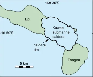
Tongoa and Epi islands once formed part of a larger island called Kuwae. Local folklore tells of a cataclysmic eruption that destroyed this island, leaving the two smaller islands. Monzier and others (1994) describe the 7.5 by 4 mile (12 x 6 km) oval-shaped caldera that formed during the eruption. They date the event at 1420-1430 A.D. Collapse associated with caldera formation may have been as much as 3,600 feet (1,100 m). Monzier and others estimated that 32-39 cubic km of magma was erupted, making the Kuwae eruption one of the largest in the last 10,000 years and comparable to Santorini and Crater Lake. Map of Kuwae submarine volcano and adjacent islands from Monzier and other (1994).
Interpreting the volcanic layers preserved on Tongoa and Epi, Robin and others (1994) suggested the caldera formed in three stages:
- moderate hydromagmatic and magmatic activity from a central vent over a period of months or years;
- hydromagmatic eruptions of dacite gradually shifting to a magmatic eruption and emplacement of two major pyroclastic flows and collapse of the caldera;
- additional eruptions of dacitic pyroclastic flows as collapse of the caldera extended north.
Sources of information on the volcanoes of Vanuatu (New Hebrides Islands).