Strato Volcanoes comprise the largest percentage (~60%) of the Earth's individual volcanoes and most are characterized by eruptions of andesite and dacite - lavas that are cooler and more viscous than basalt. These more viscous lavas allow gas pressures to build up to high levels (they are effective "plugs" in the plumbing), therefore these volcanoes often suffer explosive eruptions.
Strato volcanoes are usually about half-half lava and pyroclastic material, and the layering of these products gives them their other common name of composite volcanoes.
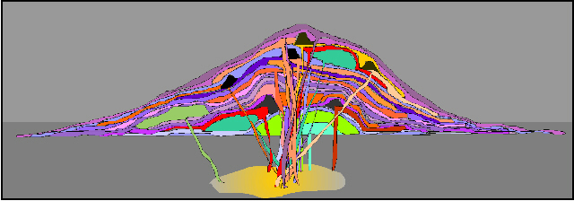
This is a schematic diagram of a strato volcano, intended to illustrate the different layers of different materials that comprise them. The purple colors are meant to represent ash layers, either the products of fall-out from big eruption clouds or the products of pyroclastic flows. Notice that these ash layers tend to be thin but widespread. The orange colors represent lava flows, and note that some of them have cinder cones associated with them at the vent. The green colors are meant to represent lava domes, and notice that they do not flow very far. Each eruption, regardless of what it produces, is fed from the magma chamber by a dike. Most dikes come up through the center of the volcano and therefore most eruptions occur from at or near the summit. However, some dikes head off sideways to feed eruptions on the flanks.
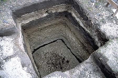
This is a pit that has been dug into the ground at Cotopaxi, a big strato volcano near Quito, the capital city of Ecuador. The pit is about 2 meters deep and in it you can clearly see a number of ash layers exposed. It is also easy to see that the layers are different - some are coarse and others are fine, some are dark-colored and others are light-colored.
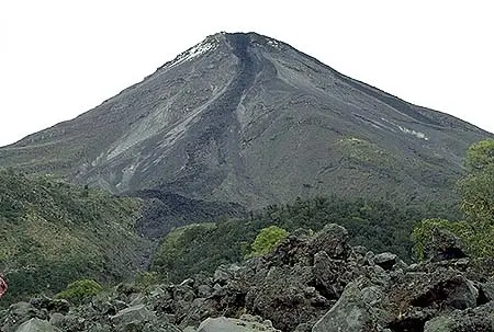
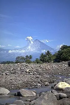
The lava at strato volcanoes occasionally forms 'a'a, but more commonly it barely flows at all, preferring to pile up in the vent to form volcanic domes. Some strato volcanoes are just a collection of domes piled up on each other. Strato volcanoes are commonly found along subduction-related volcanic arcs, and the magma supply rates to strato volcanoes are lower. This is the cause of the cooler and differentiated magma compositions and the reason for the usually long repose periods between eruptions. Examples of strato volcanoes include Mt. St. Helens, Mt. Rainier, Pinatubo, Mt. Fuji, Merapi, Galeras, Cotopaxi, and super plenty others.


Although they are not as explosive as large silicic caldera complexes, strato volcanoes have caused by far the most casualties of any type of volcano. This is for many reasons. First is that there are so many more strato volcanoes than any of the other types. This means that there will also be lots of people who end up living on the flanks of these volcanoes. Additionally, strato volcanoes are steep piles of ash, lava, and domes that are often rained heavily on, shaken by earthquakes, or oversteepened by intruding blobs of magma (or all of these). This makes the likelihood of landslides, avalanches, and mudflows all very high. Occasionally as well, entire flanks of strato volcanoes collapse, in a process that has been termed "sector collapse". Of course the most famous example of this is Mt. St. Helens, the north flank of which failed during the first stages of the big 1980 eruption. Mt. St. Helens was certainly not the only volcano to have suffered an eruption such as this, however. Two other recent examples are Bezymianny (Kamchatka) in 1956, and Unzen (Japan) in 1792. The 1792 Unzen sector collapse dumped a flank of the volcano into a shallow inland sea, generating devastating tsunami that killed almost 15,000 people along the nearby coastlines.
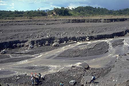
This is a photo of lahar deposits near Santa Maria volcano (Guatemala). This used to be a wide, deep river valley, and you can see the far wall of the valley where the trees are growing. The lahar deposits extend from that far wall to behind where this photo was taken. You can see that between lahar events the river cuts into the lahar deposits, but every time there is another event, it fills up again. The people give an idea of the size of stones that can be carried by a lahar.
Another very common and deadly hazard at most strato volcanoes is called a Lahar. Lahar is an Indonesian word for a mudflow, and most geologists use the term to mean a mudflow on an active volcano. Sometimes the word is reserved only for mudflows that are directly associated with an ongoing eruption (which are therefore usually hot), but that starts to make things confusing. It is probably simplest to just call any mudflow on a volcano a lahar. Lahars are so dangerous because they move quickly, and often times a small eruption or relatively small rainstorm can generate a huge lahar. The most recent huge volcanic disaster occurred at a Colombian volcano called Nevado del Ruiz in 1985. This disaster has been well-documented by numerous post-eruption studies. Nevado del Ruiz is a very tall volcano, and even though it lies only slightly above the equator it has a permanent snow and ice field on its summit. On November 13, 1985 a relatively small eruption occurred at the summit. Even though only a little bit of ash fell and only small pyroclastic flows were produced, they were able to melt and destabilize a good deal of the summit ice cap. The ice cap had already been weakened and fractured by a few months of pre-cursor seismic activity. The melted snow and ice, along with chunks of ice, surged down gullies that started high on the slopes, picking up water, water-saturated sediments, rocks, and vegetation along the way. The eruption occurred just after 9:00 pm, and about 2 and a half hours later lahars managed to travel the approximately 50 km down river valleys to the town of Armero. The lahar entered Armero at 11:30 pm as a wall of muddy water nearly 40 meters high, and roared into the city, producing an eventual thickness of 2-5 meters of mud. Somewhere around 23,000 people were almost instantly killed. The path of destruction almost exactly matches similar disasters that occurred in 1595 and 1845. It also almost exactly covered the highest lahar-designated area on the volcanic hazard map that had been prepared prior to the 1985 eruption. Unfortunately that map had not yet been distributed by the time of the 1985 eruption.
Another place that is starting to get really tired of lahars is Pinatubo, in the Philippines. The 1991 Pinatubo eruption was the second largest this century (after Katmai in 1912), and deposited a huge volume of relatively loose pyroclastic material on already-steep and gullied slopes. Additionally, the rainfall in the Philippines is very high. The combination of all this unconsolidated material and heavy rainfall has generated probably hundreds of lahars, some of which have been enormous. Timely evacuation meant that only a couple hundred people were killed directly by the 1991 eruption. Many times that many have been killed or injured by lahars since the 1991 eruption. These lahars will continue to be a problem for decades after the big eruption.