Sinuous rilles are probably the most recognizable of small volcanic features on the Moon. Many partially resemble river valleys on the Earth. However, the lunar rilles usually flow away from small pit structures. Also, the lunar samples indicate that the Moon has always been bone dry. Thus, the sinuous rilles probably mark lava channels or collapsed lava tubes that formed during mare volcanism. Still, in some cases, the lunar flows may have melted their way down into older rocks, much like rivers cut into their flood plains on Earth. Similar lava channels and tubes are found in Hawaii, but these are all much, much smaller than those found on the Moon.

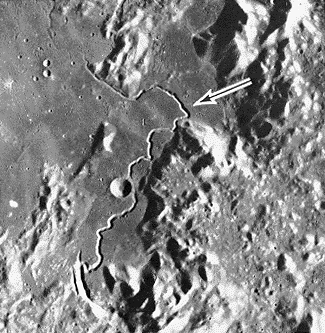
This photo shows the Hadley Rille on the southeast edge of Mare Imbrium. It is fairly well known because Apollo 15 landed there (see next image). The rille begins at the curved gash in the bottom left corner, and is clearest in the rectangular, mare-floored valley shown here. In the upper left, it gets much shallower and it slowly fades out of sight in Palus Putredinis. In all, the rille is over 75 miles (120 km) long. It is up to 5000 feet (1500 m) across and is over 950 feet (300 m) deep in places. It formed nearly 3.3 billion years ago . In contrast, lava channels on Hawaii are usually under 6 miles (10 km) long and are only 150 - 300 feet (50-100 m) wide. This contrast in channel size probably reflects (1) differences in the volume of erupted lava and (2) the difference in gravity. Note -- The bright bumps surrounding Hadley are peaks of the Montes Apenninus. These mountains mark the edge of the impact basin holding Mare Imbrium. They rise from 6000 to 15,000 feet (1800 - 4500 m) above the mare. (Apollo 15 image M-1135, arrow marks landing site of Apollo 15. Image taken from NASA SP-469, Geology of the Terrestrial Planets)

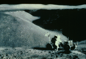
This is a photo of Hadley Rille from the lunar surface. Astronaut James Irwin is standing in the foreground by the lunar rover. At this point, the rille is nearly a mile wide (1.6 km). Note the many boulders on the Valley floor. These rocks have apparently rolled off of the Valley wall over time. Thus, any lava flows inside the rille are now buried by an unknown amount of rocks and soils. The rille appears to have cut down through a couple of older lava flows, however. These flows are probably the only actual bedrock seen by astronauts on the Moon. They form small cliff faces near the top of the rille wall in the distance. Due to the loose soil and steep slopes above these cliffs, however, no samples were taken of these units. (Apollo Photograph AS15-84-11450)

This image shows a sinuous rille located in the crater Posidonius. The source of this rille is a shallow pit on the northern crater wall (arrow). The rille then meanders along the edge of the crater floor for over 60 miles (100 km). Finally, it reaches a hole in the crater rim and vanishes into Mare Serenitatis. Note that the rille is also only the last stage of mare volcanism within this crater. It lies on top of an older, smooth mare unit which buries part of the crater floor and much of the western crater wall. ( The black bar in the lower right is about 6 miles (~10 km) long.) (Lunar Orbiter image IV-86-H3)

This image shows a chain of small pits and ridge segments. It marks the likely site of a partially collapsed lava tube in western Mare Imbrium. Here, instead of a surface lava channel, lava flowed through a buried tunnel in the mare. After the eruption stopped, the tunnel then emptied. Where the roof of the tunnel has fallen in, we see pits. If the entire roof had fallen in, we might see a sinuous trough like other lunar rilles. Thus, it is believed that some lunar rilles mark collapsed lava tubes. These rilles are usually near other collapse pits, and some also merge with ridge-like features. Thus, uncollapsed lava tubes may still exist near some of these lunar sinuous rilles. (Lunar Orbiter image V-182-M, from Wilhelms (1987) The Geologic History of the Moon, USGS Prof. Paper 1348.)

This photo shows Schroter's Valley (arrow) and the Aristarchus Plateau. It lies between Mare Imbrium and Oceanus Procellarum. This valley is the largest (widest) sinuous rille on the Moon. It also has a smaller rille inside it (see next photo). Both rilles come from the same vent, but they probably reflect two separate eruptions. Both rilles fade away into the plains of Oceanus Procellarum. (Apollo 15 image M-2611, from Wilhelms (1987) The Geologic History of the Moon, USGS Prof. Paper 1348.)

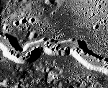
This is a detailed photo showing part of Schroter's Valley (see last image). It clearly shows a complex, highly contorted rille inside the Valley. Like many rivers on the Earth, this rille has many tight loops along its course. These loops are meanders, and they suggest a long-lived flow on a fairly flat surface. They also require active erosion of the valley floor. This channel may have partially melted its way into older lava flows. (Part of Apollo 15 image P-341.