Last update: October 14, 2002
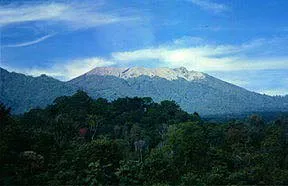
Raung is a stratovolcano with a circular summit caldera. A prehistoric collapse on the west flank of the volcano produced a large debris avalanche that traveled about 40 miles (60 km). Raung has erupted at least 57 times since 1593. Most eruptions consisted of moderate size explosions (VEI=2). The explosive eruption in 1593 was very large (VEI=5) and caused fatali ties. Eruptions in 1597, 1638, 1730, and 1817 also caused fatalities. A crater lake was present during the eruptions of 1586, 1593, 1597, 1638, 1730, 1817, and 1838. Mudflows were generated during the eruptions of 1638, 1730, 1817, and 1838. More than 1,000 people were killed by floods and lahars between the Stail and Klatak Rivers during the 1638 eruption. Photo shows Raung from the floor of Ijen caldera.

Space Shuttle photo STS049-097-050 taken in May 1992 and looking northeast across Ijen Caldera and Raung.
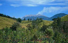
The most recent lava-producing eruption at Raung was in 1973. The lava was confined to the summit caldera. An eruption of Raung in July of 1982 sent dark clouds of ash to 18,000 feet (6,000 m). Smaller explosions occurred the next two days. Aircraft were diverted from the area. An eruption in November and December of 1985 included more than 50 small explosions. Raung as seen from the east side of Ijen caldera.
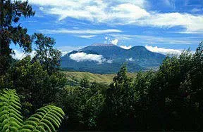
Raung erupted in 1993 and 1995. The most recent eruption of Raung was in June of 1997 when ash was observed at heights of 3 miles (5 km) above the volcano. Raung as seen from the active cone on Ijen. All photos by Steve Mattox. June 28, 1997.
October 1, 2002
Volcanic activity decreased significantly this week. Only a few white clouds rose 100 m above the summit. On September 30th, the Alert Level decreased from 4 to 3 (on a scale of 1-4).
This information was summarized from the GVP/USGS Weekly Volcanic Activity Report
September 26, 2002
The Alert Level was increased to 4 (the highest level) after the beginning of the eruption on September 25th at 01:00. During the initial phase, the ash cloud rose 0.5 to 1 km above the summit. During the second eruption erupted, at 11:40, an ash cloud rising to 5 km above the summit was visible. Satellite imagery indicated that a 16-km high ash cloud was also produced. The surrounding population of desa Pumpente and desa Laimpatehi was evacuated.
This information was summarized from the GVP/USGS Weekly Volcanic Activity Report
Sources of Information:
McClelland, L., Simkin, T., Summers, M., Nielsen, E., and Stein, T.C., 1989, Global Volcanism 1975-1985: Englewood Cliffs, New Jersey, Prentice Hall, 655 p.
Simkin, T., and Siebert, L., 1994, Volcanoes of the World: Geoscience Press, Tucson, Arizona, 349 p.