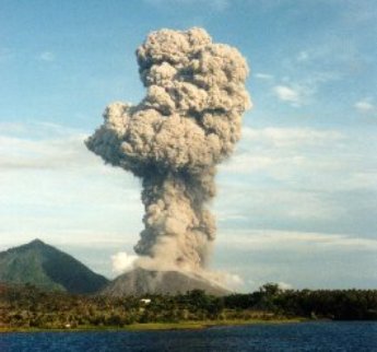
 Photo Credit: Bryan Birch Volcano Explositivity Index: 4 The low-lying Rabaul caldera on the tip of the Gazelle Peninsula at the NE end of New Britain forms a broad sheltered harbor utilized by what was the island's largest city prior to a major eruption in 1994. The outer flanks of the 688-m-high asymmetrical pyroclastic shield volcano are formed by thick pyroclastic-flow deposits. The 8 x 14 km caldera is widely breached on the east, where its floor is flooded by Blanche Bay and was formed about 1400 years ago. An earlier caldera-forming eruption about 7100 years ago is now considered to have originated from Tavui caldera, offshore to the north. Three small stratovolcanoes lie outside the northern and NE caldera rims of Rabaul. Post-caldera eruptions built basaltic-to-dacitic pyroclastic cones on the caldera floor near the NE and western caldera walls. Several of these, including Vulcan cone, which was formed during a large eruption in 1878, have produced major explosive activity during historical time. A powerful explosive eruption in 1994 occurred simultaneously from Vulcan and Tavurvur volcanoes and forced the temporary abandonment of Rabaul city. (description courtesy of the USGS)
The eruption of Rabaul was probably the most important eruption of 1994. Certainly the eruption did more damage than any in nearly a decade. Large portions of the town of Rabaul were destroyed by ash from the eruption. Just what happened at Rabaul? Rabaul, the town, is inside Rabaul, an 8 x 14 km (~5 x 9 mile) wide caldera that is mostly filled by Blanche Bay, an arm of the ocean. Its pretty dangerous to have a town inside of a volcano, but there have been no eruptions there for 51 years.
On the morning of September 19, 1994, two volcanic cones - Vulcan and Tavurvur - began erupting on the opposite side of the harbour from the town. By 10:30 AM an airplane pilot reported that the ash cloud was 15-18 km (9-11 miles) above Rabaul. Other estimates placed the top of the cloud as high as 30 km (~18 miles). This was a powerful eruption! Ash fell all over the town and satellite photographs showed an ash cloud carrying volcanic dust westward over much of New Guinea. The ash that fell over the town was first reported to be 20-25 cm (8-10 inches) deep, and it later was as much as 75 cm deep (about two feet). Heavy rains turned the ash into mud that fianlly dried to be nearly as hard as cement. The roofs of many buildings collapsed from the weight of the ash. A small lava flow came from a vent near Tavurvur and flowed slowly for about 25 days. Also, some of the clouds of ash eruptions collapsed back on themselves and a mixture of ash and gases flowed rapidly down the side of the volcanoes and out into the bay. Such ash and gas mixtures are called pyroclastic flows. Pyro is a Greek work for fire, and clastic is Greek for broken pieces of rock. Some of the ash and pyroclastic flows made floating rafts of pumice.
The eruptions declined in strength, and by Oct. 2, Vulcan was no longer erupting; Tavurvur continued throughout October and November. Despite the great danger of this eruption, only five people died; four from collapses of roofs, and one person was struck by lightning. The reason so few people were hurt is that volcanologists at Rabaul had been expecting an eruption someday. They had educated the people of Rabaul to the dangers of volcanic eruptions and even practiced eruption drills - sort of like fire drills in a school. When intense earthquakes started the night before the eruption, the volcanologists and government officials evacuated nearly all of the town people before the eruption started. This was a tremendous success for science, for that night and the next few days, nearly 50,000 people were removed from a place of great danger to safety. Rabaul did not become a great tragedy, but was a great triumph!
Click here to learn more about the Rabaul Caldera. Click here to learn more about the 1994 Rabaul eruption. |