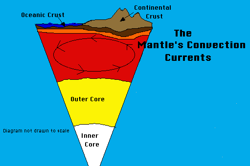
The Earth is a dynamic or constantly changing planet. The thin, fragile plates slide very slowly on the mantle's upper layer. This sliding of the plates is caused by the mantle's convection currents slowly turning over and over. This overturn is like a conveyor belt that moves the plates of the crust.
These plates are in constant motion causing earthquakes, mountain building, volcanism, the production of "new" crust and the destruction of "old" crust. The following cards will teach you more about the Earth's plates.
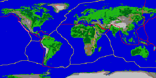
The Earth's crust is broken into many pieces. These pieces are called plates. There are twelve main plates on the Earth's surface. The red lines on this map of the world represent the largest plate boundaries. A plate boundary occurs where two plates come together. There are three kinds of plate boundaries:
1. Convergent boundary -where two plates collide to form mountains or a subduction zone.
2. Divergent boundary -where two plates are moving in opposite directions as in a mid-ocean ridge.
3. Transform boundary -where two plates are sliding past each other as in the San Andreas fault of California.
The Earth's plates are in constant, but very, very slow motion. They move at only 1/2 to 4 inches (1.3 to 10 centimeters) per year!! This does not seem like much, but over millions of years it adds up to great distances of movement.
The Continental Drift Theory states that the continents have moved and are still moving today. In 1912 Alfred Wegener introduced this theory, but he did not fully understand what caused the plates to move. A theory is an explanation of a scientific process that has been successfully tested by many different methods.
The motion of the Earth's plates help scientists to understand why earthquakes, volcanoes, and mountain building occur.
You will learn more about why the plates are moving in the next lesson, "How Plates Move".
Scientists believe these plates have been moving for millions of years. In fact, 250 millions years ago the Earth's seven continents were all grouped together into a supercontinent called Pangea.
Just before the days of the dinosaurs the Earth's continents were all connected into one huge landmass called Pangaea . This huge supercontinent was surrounded by one gigantic ocean called Panthalassa.
Notice the postion of the continents of Antarctica (Far north of its current position), Australia (flipped sideways and far west of its current position) and the subcontinent of India (Hundreds of miles from Asia).
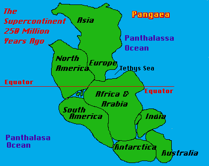
Scientists believe that the North American continent was located much farther south and east of it's position today. In fact, much of North America was in or near the tropics!! How do scientists know this?? They have found fossils from this period of time. These fossils are of tropical plants and animals. The fossils have been found in cold regions like North Dakota and Greenland!!!
180 Million Years Ago
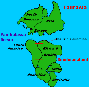
About 180 million years ago the supercontinent Pangea began to break up. Scientists believe that Pangea broke apart for the same reason that the plates are moving today. The movement is caused by the convection currents that roll over in the upper zone of the mantle. This movement in the mantle causes the plates to move slowly across the surface of the Earth. About 200 million years ago Pangaea broke into two new continents Laurasia and Gondwanaland. Laurasia was made of the present day continents of North America (Greenland), Europe, and Asia. Gondwanaland was made of the present day continents of Antarctica, Australia, South America. The subcontinent of India was also part of Gondwanaland. Notice that at this time India was not connected to Asia. The huge ocean of Panthalassa remained but the Atlantic Ocean was going to be born soon with the splitting of North America from the Eurasian Plate.
How do we know that South America was attached to Africa and not to North America 180 million years ago?
Scientists today can read the history of the rock record by studying the age and mineral content of the rocks in a certain area.
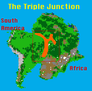
The Triple Junction was formed because of a three-way split in the crust allowing massive lava flows. The split was caused by an upwelling of magma that broke the crust in three directions and poured out lava over hundreds of square miles of Africa and South America.
The rocks of the triple junction, which today is the west central portion of Africa and the east central portion of South America, are identical matches for age and mineral make up. In other words the rocks in these areas of the two continents were produced at the same time and in the same place. This tells us that South America and Africa were connected at one time!
Today these two continents are separated by the Atlantic Ocean which is over 2000 miles wide!
135 Million Years Ago

About 135 million years ago Laurasia was still moving, and as it moved it broke up into the continents of North America, Europe and Asia (Eurasian plate). Gondwanaland also continued to spread apart and it broke up into the continents of Africa, Antarctica, Australia, South America, and the subcontinent of India. Arabia started to separate from Africa as the Red Sea opened up.
The red arrows indicate the direction of the continental movements. Notice how far the Indian subcontinent has to move to get to its present postion connected to Asia.
The Atlantic, Indian, Arctic, and Pacific Oceans are all beginning to take shape as the continents move toward their present positions.
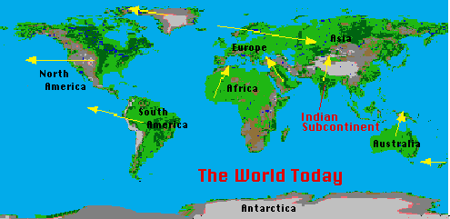
The plates are still moving today making the Atlantic Ocean larger and the Pacific Ocean smaller. The yellow arrows on the world map indicate the direction of plates movements today.
Notice the position of the Indian Subcontinent today. It moved hundreds of miles in 135 million years at a great speed (4 inches per year!!!) The Indian plate crashed into the Eurasian plate with such speed and force that it created the tallest mountain range on Earth, the Himalayas! What do you predict the world will look like in 100 million or 200 million years? What new mountain ranges will form? Where will new volcanoes erupt?
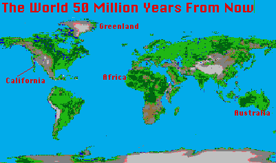
The Atlantic Ocean will be much larger 50 million years from now and the Pacific Ocean will be much smaller. North and South America will have moved farther west (California moving north) while Greenland will be located farther west but also farther north. The western part of Africa will rotate clockwise and crash into Europe causing great mountain building, while the far eastern region of Africa will rotate eastward toward the Arabian peninsula. Australia will move farther north into the tropics, while New Zealand will move to the south of Australia.
All of these predictions are just that, predictions. These movements of the continents may happen if the plates continue to move in the same direction and with the same speed as they are moving today. Scientists are not certain of the movement today, let alone 50 million years into the future.
What do you think the world will look like in 50 million years???
Write the answers for the questions on a sheet of paper. When you finish the lesson click on the "Earth" icon so that the next pair of students will be at the start of the lesson.
1. What caused Pangea to break up?
2. What is the Continental Drift Theory?
3. What happened at the Triple Junction? Where is it located today?