
Mount Napier, Victoria, Australia. The Newer Volcanics Province covers an area of 6,000 square miles ( 15,000 square km) and contains over 400 vents. Mount Napier, one of the youngest volcanoes in Australia, is a composite lava shield with a superimposed scoria cone. The cone rises 500 feet (150 m) above the surrounding plains to an elevation of 1,440 feet (440 m), making it the highest point on the Western District Plains of Victoria. It erupted about 5,290 BC. (Peter Whitehead, 1986)

The main crater of Mount Napier, showing a spatter rampart 100 feet (30 m) long and 15 feet (5 m) high. The crater is about 150 feet (50 m) in diameter and 60 feet (20 m) deep. (Peter Whitehead, 1986)
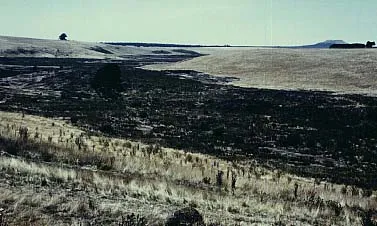
In the Harman Valley, lava from Mount Napier, in the background, flowed for over 9 miles (15 km) to a depth of over 100 feet (30 m). (Peter Whitehead, 1986)

The entrance to Bridge Cave in the Harman Valley flow of Mount Napier. This is one of a series of aligned lava tubes, presumably formed from the same flow. The lava tubes descend to over 60 feet (20 m) below the surface of the Harman Valley. (Peter Whitehead, 1986)
This contribution by Peter Whitehead of James Cook University, Queensland, Australia.
For more information on Australian volcanic parks, visit Mt. Eccles National Park, Victoria, Australia.
Sources of Information:
Johnson, R.W., Knutson, J., and Taylor, S.R., editors, Intraplate volcanism in Eastern Australia and New Zealand, Cambridge, England: Cambridge University Press, 408 p.
Simkin, T., and Siebert, L., 1994, Volcanoes of the World: Geoscience Press, Tucson, Arizona, 349 p.