
General map of the Osumi Islands showing the location of Kikai Caldera. The location of Kuchinoerabu-jima, an active stratovolcano with numerous historic eruptions, is also shown.
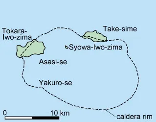
Simple map of Kikai Caldera. Syowa-Iwo-zima is a small island that formed during a submarine eruption in 1934 that produced a lava dome. The dome rises only 26 m above sea level and is 500 by 300 m. From Kuno (1962).
Kikai is a submarine caldera with three small islands, parts of the caldera rim, that project above sea level. The caldera is about 19 km in diameter. Submarine topography suggests the presence of a double collapse structure. Three large silica-rich eruptions have been produced by Kikai. The most recent caldera-forming eruption was about 6,300 years ago and was the largest eruption on Earth in the last 10,000 years. About 150 cubic km of ash was erupted. The volcanic explosivity index for the eruption was 7 (there have only been three other VEI=7 eruptions in the last 10,000 years: Tambora 1815, Baitoushan ca. 1050, and Crater Lake, 4895 BC). The eruption sent pyroclastic flows 100 km across the sea to southern Kyushu and ash fell across all of Japan. Eruptions since 6,300 years ago have been bimodal with several silicic vents and one basalt vent forming. The most rest unrest at Kikai was in 1988 when gray plume rose about 500 m above the Iwo-dake summit crater.
Space Shuttle photo STS61A-0468-0001 of southern Kyushu and the Osumi Islands.
| Chemicals | 1 | 2 | 3 |
|---|---|---|---|
| SiO2 | 55.04 | 66.99 | 64.51 |
| Al203 | 14.60 | 13.90 | 16.25 |
| FeO* | 5.58 | 5.36 | 5.02 |
| MgO | 5.19 | 1.06 | 2.33 |
| CaO | 9.13 | 4.45 | 5.42 |
| Na2O | 1.76 | 3.49 | 3.41 |
| K2O | 0.41 | 1.82 | 1.66 |
| TiO2 | 0.80 | 0.31 | 0.24 |
| P2O5 | 0.43 | 0.31 | 0.19 |
| MnO | 0.22 | 0.09 | 0.12 |
FeO* = total FeO
- Lava of Imaura-dake.
- Lava of Iwo-dake. Average of three analyses.
- Lava of Syowa-Iwo-zima. Average of four analyses.
Sources of Information:
Aramaki, S., 1984, Formation of the Aira Caldera, southern Kyushu, about 22,000 years ago: Journal of Geophysical Research, v. 89, p. 8485-8501.
Kuno, H., 1962, Part XI, Japan, Taiwan and Marianas: Catalogue of the active volcanoes of the world including solfatara fields, International Association of Volcanology, Rome, Italy, 332 p.
Machida, H., and Arai, F., 1983, Extensive ash falls in and around the Sea of Japan from large late Quaternary eruptions: Journal of Volcanology and Geothermal Research, v. 18, p. 151-164.
Ui. T., 1973, Exceptionally far-reaching, thin pyroclastic flow in southern Kyushu: Bulletin. Volc. Society Japan, v. 18, p. 153-168.