
Kanaga is one of the most southerly stratovolcanoes in the Aleutian arc. This nearly symmetric volcano was constructed in an older caldera called ancient Mount Kanaton. It has had seven know eruptions since 1763. The most recent eruption was in 1994. This photo of Kanaga is to the northwest from Adak Island.

Kanaga volcano. The rim of the older caldera can be seen behind Kanaga.
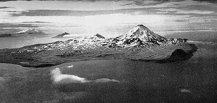
Aerial view of Kanaga volcano from the east. The rim of the ancient caldera is to the left of the symmetrical cone. Plate 6 from U.S. Geologic Survey Bulletin 1028-D.
Sources of Information:
Coats, R.R., 1952, Magmatic differentiation in Tertiary and Quaternary volcanic rocks from Adak and Kanaga Islands, Aleutian Islands, Alaska: Geologic Society of America Bulletin, v. 63, p. 485-514.
Coats, R.R., 1956, Geology of northern Kanaga Island, Alaska: U.S. Geologic Survey Bulletin 1028-D, p. 69-81.
Simkin, T., and Siebert, L., 1994, Volcanoes of the World: Geoscience Press, Tucson, Arizona, 349 p.
Wood, C.A., and Kienle, J., 1993, Volcanoes of North America: Cambridge University Press, New York, 354 p.