The first thing you notice when the plane lands in Antofagasta is that there is no vegetation on the landscape that hasn't been planted there. This is because rain in Antofagasta is extremely rare, averaging less than 4 mm a year with recorded rain-free droughts of over 40 years! (Vargas, et.al., 2000) Instead, it is the brightly colored houses and shops that bring color to the landscape.
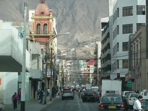
Antofagasta is a prominent port town and has a population of over a quarter of a million people - the fourth largest in Chile. Because of its proximity to the mines, much of the economy in town is in support of the mining industry.
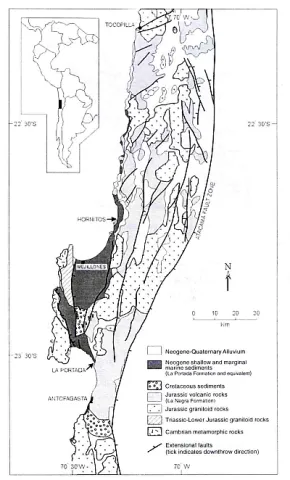
Geology
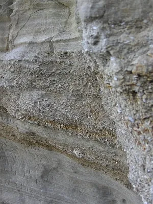
The City of Antofagasta is underlain by Jurassic era basaltic andesite lava's known as the La Negra Formation. (Ferraris and Di Biase, 1978) These lava's are overlain by sandstone that is often embedded with or covered by dense layers of shells (see photo below) and local pebbles formed from a Pleistocene marine terrace. (Ortlieb, 1995)
La Portada
18 kilometers north of Antofagasta is the famous La Portada (which means The Portal or Gateway in Spanish). La Portada is a 140 foot tall archway of sandstone (resting on top of the La Negra) formed from continuous marine erosion of the shoreline cliffs.
Some Field Notes
Our goal in Antofagasta was to get supplies and rent reliable transportation. Hertz was in town and had two four-wheel drive trucks (a MUST) ready to go and proved to be an excellent choice because of their customer service. (We had a truck burn a clutch halfway through the trip and they drove a replacement out to meet us in less than a day!) Renting two cars ensures that you will be able to drive out should something go wrong... because on the Altiplano, you do not want to break down without another way out. Also, there are no gas stations past Calama on our journey. So, we packed in all the gasoline, water, food, cooking equipment, field gear, and camping gear into the two trucks.
Speaking of water... there is none. What naturally occurring fresh water there is has filtered through run-off from the mines and has been known to contain high levels of arsenic. (Pérez-Carrera et.al, 2010; Borgoño et.al, 1976) Today, the city gets much of its water from sea water desalinization. Either way, bottled water is a good idea in the city and an absolute must beyond this point on during the trip. With the change in elevation and the amount of running around we did each day, staying hydrated was difficult at best. You cannot have too much water! (and remember... Con Gas = with bubbles, Sin Gas = without)

Additional Sources
- Ferraris, F.; Di Biase, F. 1978. Hoja Antofagasta. Instituto de Investigaciones Geológicas de Chile, Carta Geológica de Chile, No. 30, 48 p.
- Borgoño, J.M., et al. Environ Health Perspect. 1977 August; 19 : 103–105.
- Boric, R.; Díaz, F.; Maksaev, V. 1990. Geología y Yacimientos Metalíferos de la Región de Antofagasta. Servicio Nacional de Geología y Minería, Boletín, No. 40, 246 p.
- Hartley, et al., Rev. geol. Chile v.28 n.1 Santiago jul. 2001
- Ortlieb, L. 1995. Late Quaternary coastal changes in northern Chile: fieldguide for International Geological Correlation Program Project 367, Late Quaternary records of Coastal Change, Annual Meeting, 1995. Orstom, 175 p. Antofagasta, Chile.
- Pérez-Carrera, A. and Cirelli, Alicia. 2010. Arsenic and Water Quality Challenges in South America in Water and Sustainability in Arid Regions, Part 3. SpringerLink Publishing, Netherlands. ISBN 978-90-481-2775-7.
- Shiki, T.; Yamazaki, T. 1996. Tsunami-induced conglomerates in Miocene upper bathyal deposits, Chita Peninsula, central Japan. Sedimentary Geology, Vol. 104, p. 175-188.
- Vargas, G. et al., Aluviones históricos en Antofagasta y su relación con eventos El Niño/Oscilación del Sur, Rev. geol. Chile vol.27 n.2 Santiago Dec. 2000.