
The isolated volcano of Dukono at the northern end of Halmahera Island, is one of Indonesia's most active. Seen here in June 1991, Dukono has a broad profile and is capped by many compound craters. Dukono has displayed more or less continuous explosive activity since 1933, occasionally accompanied by lava flows.
Dukono is a complex volcano and one of the most active volcanoes in Indonesia in historic time. The first historic eruption was in 1550. The eruption was explosive (VEI=3) but also produced lava flows. Deaths and damage were reported but details are not known. Dukono had smaller eruptions in 1719, 1868, and 1901. Dukono has been erupting continuously from 1933 to the present. Eruptions have been explosive (VEI=3) and also produced lava flows and mudflows. The eruptions have caused damage but no deaths. Volcanologists visited the volcano in 1978 and 1979. On the first visit, bombs as long as 4 m were being thrown as far as 250 m from the vent. An ash cloud rose up to 10 km above the crater. Ash was blown as far away as 15 km. Quiet periods lasting 6-8 hours were reported. On the second visit, explosive ejection of ash was observed.

Mt. Dukono crater, North Halmahera. May 2000.
Reports from this remote volcano in northernmost Halmahera are rare, but Dukono has been one of Indonesia's most active volcanoes. More-or-less continuous explosive eruptions, sometimes accompanied by lava flows, occurred from 1933 until at least the mid-1990s, when routine observations were curtailed. During a major eruption in 1550, a lava flow filled in the strait between Halmahera and the north-flank cone of Gunung Mamuya. Dukono is a complex volcano presenting a broad, low profile with multiple summit peaks and overlapping craters. Malupang Wariang, 1 km SW of Dukono's summit crater complex, contains a 700 x 570 m crater that has also been active during historical time. (Description courtesy of the Global Volcanism Program)
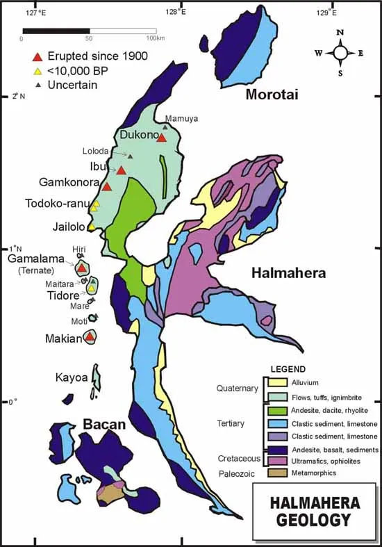
Geologic map of Halmahera, Indonesia.
Sources of Information:
Carlile, J.C., Davey, G.R., Kadir, I., Langmead, R.P., and Rafferty, W.J., 1998, Discovery and exploration of the Gosowong epithermal gold deposit, Halmahera, Indonesia: Journal of Geochemical Exploration, v. 60, p. 207-227.
Kusumadinata, K., 1977, Data on the Dukono volcano; Berita Direktorat Geologi, v. 9, no. 16, p. 183.
McClelland, L., Simkin, T., Summers, M., Nielsen, E., and Stein, T.C., 1989, Global Volcanism 1975-1985: Englewood Cliffs, New Jersey, Prentice Hall, 655 p.
Simkin, T., and Siebert, L., 1994, Volcanoes of the World: Geoscience Press, Tucson, Arizona, 349 p.