Tectono-Volcanic Structures

REFERENCE MAP (Tectonic/Volcanic Features)
Volcanism is also part of some very complex features on Venus. These features mix both lavas and faulting; thus, they are called TECTONO-VOLCANIC structures. They differ from volcanoes in two ways. First, volcanoes often form on older rifts or faults, but they do not cause this faulting. Second, most volcanoes are just large piles of lava. In contrast, the tectono-volcanic structures are thought to form by faulting over rising magmas. Also, lavas make up only a small part of these structures. Due to differences in faulting, three types are found on Venus.
Coronas
Some 200 to 300 coronas are known, of which 175 are mapped above. These are large, round to oval shaped features with a distinct ring of faults or ridges. They often have a flat, raised or down-dropped center and an outer moat-like trough. Lava plains and small shields are found in both the centers and the moats, and pancake domes are very common as well. Coronas range in size from about 100 km to nearly 1000 km, but most are 200 to 250 km across.
Coronas are thought to form over small mantle plumes. First, rising magmas and heat lift the surface. These plumes also feed local eruptions, but they are too small for a long string of eruptions. Thus, the uplifted surface is not fully buried, and a complex mix of faults and lavas is formed. With later cooling, the uplift then sinks to yield the down-dropped centers seen in the oldest coronas.
Arachnoids
Arachnoids are smaller cousins of the coronas. Like coronas, they have a round ring of faults or ridges, but these rings lie inside a set of radial ridges. The rings range from about 50 km to 200 km in size, with the outer ridges running out another 200 to 400 km. Over 250 arachnoids have been mapped, and they tend to cluster near both coronas and other arachnoids. Also, like the coronas, arachnoids are rarely found in the lowest plains. Instead, most lie just above the lowland plains (i.e., the green map areas).
Arachnoids look like coronas and form near coronas. Thus, they are thought to form in much the same way as coronas. They are smaller than most coronas, however, and they tend to show fewer lavas. Thus, they probably formed over smaller plumes. Since smaller plumes should have less magma and should cause less uplift, this model seems to fit the facts. However, the lack of lava flows also suggests that there are more intrusions in arachnoids than in coronas. Indeed, it has been suggested that the radial ridges may be large dikes. In this case, these dikes could drain magmas away from the plume and limit the eruption of lavas at the surface.
Novas
Novas show fewer signs of real volcanism than the coronas or the arachnoids. Instead, they show a starburst-like pattern of faults and a broad, dome- like uplift. Some of these faults seem to feed lava flows, but such flows are not common. About 50 Novas have been mapped, with sizes ranging from about 50 km to 300 km. Most are between 150 and 200 km across, and thus are the same size as many of the arachnoids. Although rare, novas tend to occur near large volcanoes or near groups of coronas and arachnoids. They are seldom found alone or in the lowland plains. Since the higher plains on Venus are thought to lie over mantle plumes, this suggests that novas are linked to mantle melting in some way. Given their size and shape, they may mark an early stage of uplift over small mantle plumes. If this is true, then these novas may turn into arachnoids or coronas in a few million years.
Mylitta Fluctus
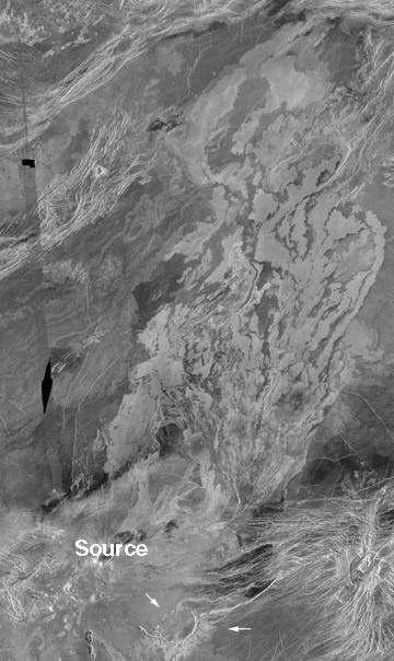
Mylitta Fluctus is one of the largest lava flow fields on Venus. It is about 1000 km long (600 miles) by 460 km wide. Thus, it covers an area slightly larger than the state of Arizona (300,000 square km). It lies on the southern edge of Lavinia Planitia, and drops some 2000 meters from south to north. Note the large crater which is partly flooded in the southeast (arrows).
This flow field contains many lava flows. These vary in length from 400 to 1000 km, and form ~30 km to 100 km in width. Many of these flows contain central lava channels like those seen on Hawaii. The flows seem to have formed in 6 separate eruptions, and most come from a single center in the southeast (marked source). This source is a large shield volcano that was formed by the first eruption event. The later eruptions then produced the longer flows of the main flow field. On the basis of Earth lavas, it is thought that the shield formed in about 10 to 70 years. Each of the later lava flow sets could have formed in less than 2 to 80 days.
Note: While Flood Basalts on the Earth are as large as Mylitta Fluctus, most Flood Basalts do not come from a single source. Rather, they come out of long fissures which are buried by the erupted lavas. Thus, the flow of lavas away from the shield here suggests that it may be harder for lavas to reach the surface on Venus. Since the shield lies on a major rift zone, faulting may have helped these lavas reach the surface.
(Image from Magellan C2 MIDR 60S333;1, with parts from C2 60S333;202.)
Atla Flow Field

This image shows another lava flood field. This one lies on the edge of Atla Regio, and is also about 1000 km long. At its widest, it is nearly 300 km across, but it also narrows down less than 50 km in some places. In area, it is roughly the same size as state of Oklahoma (~180,000 square km).
Like Mylitta Fluctus, this flow field formed in several stages. Here, however, there is no shield volcano at the source. Rather, the lavas erupted four times from a small group of faults and graben. Like Mylitta, these faults are part of a larger rift system. After eruption, the lavas then flowed west along the edge of Atla Regio. Note how they arc around to follow the lowest ground, and then flow into a smaller rift.
(Image from Magellan C1 MIDRs 00N197 and 00N215.)
Meandering Channel

This is one part of a long lava channel in Helen Planitia. In all, the channel has a total length of almost 1200 km, but the segment shown here is only 200 km long. It is also about 2 km wide. Note how the channel snakes along in a band that is slightly brighter than the surrounding plains. This band probably formed from thin lavas that flowed over the channel's banks. In addition, a much older lava channel can also be seen. The marked pair of bright lines (arrows) seems to mark a channel that has almost totally faded away into the nearby plains.
Although well preserved, the main channel also seems to be old. First, its ends fade away into the plains lavas. This suggests that the channel has been buried in places by younger lavas. Second, the channel is cut by a swarm of ridges and faults (see upper center). Probably, the channel formed soon after the local plains, and both then saw nearly 300 million years of slow deformation.
(Press Release Image P39226, MGN-82, centered near 49S, 273E.)
Relict Channels

This is part of another lava channel. It lies just south of Ishtar Terra, and also is about 2 km wide. It clearly shows a set of cut-off channels and islands that look much like those seen on some Earth rivers. Thus, it seems that the lavas changed their path over time much like EarthUs rivers. Clear signs of erosion are also seen inside the channel in the upper right. Thus, it looks as if the lavas cut down into older flows. These changes in the flow path are likely the result of later lava flows using an older channel. Still, they might also have formed during one very long eruption.
(Image is part of Magellan F MIDR 45N019.)
Braided Channel Segment

Venusian channels also form more complex systems. Here, we see one part of such a system. In the upper left are several channels that formed when lavas spilled out of a fault-bounded trough. These channels merge in the center of the image, and then run into a ridge of highlands. The lavas pooled behind this ridge, before spilling over it too to flow further east. In the process, they carved deep outlets through the highlands (see arrows) and left a number of stream-lined islands.
These islands, at both the left and right, look much like features carved by large floods on the Earth and on Mars. Thus, it is thought that the lavas in this channel behaved much like flood waters on the Earth. Given the slow speed of most Earth lavas, this in turn suggests that the lavas were not basalts. Rather, they may have been very hot mantle melts (komatiites), or possibly liquid sulfur. For reference, this image is about 250 km wide. It shows part of a 1200 km long channel which flows around the Ammavaru volcanic complex. It lies in the south near Lada Terra.
(Image is part of Magellan F MIDR 50S021, and is centered near 51S, 22E.)
Sinuous Rilles

This image shows shorter sinuous rilles more like those seen on the Moon. Here, the smallest rilles begin at small or middle-sized round pits. The larger rilles begin at bigger, more complex collapse zones. Note how the rilles narrow away from these sources. This suggests that the lavas slowed and cooled as they moved away from the source vent. Thus, these eruptions were likely smaller and more short lived than the eruptions that formed longer lava channels. Also note how the source pits line up with the older faults in this image. Once again, these faults probably helped control where the lavas could reach the surface.
(Image part of Magellan C1 MIDR 15S095, centered near 11S, 89.5E.)
Small Caldera

This caldera shows what most calderas on Venus look like. The central hole is about 36 km across, and it is surrounded by a large set of arcuate faults. These form a bulls-eye pattern over 100 km across. Note that these faults also cut a ring of lava flows that formed before the caldera fell in. Inside the caldera, the floor is made of dark, smooth lavas that erupted after collapse. Even after these lavas, however, the floor still rose and fell a few more times. This is shown by the ring of faults inside the floor and by the faults at the caldera's center.
Impact craters also are round holes, but most craters and calderas do not look alike. First, impact craters almost never have a bulls-eye of faults outside their rims. Second, where most impact craters have sharp, raised rims, most calderas have low, rounded rims like that seen here. Third, most impact craters of this size have a clear peak rising out of the crater floor. Calderas mostly have smooth floors. Lastly, calderas often have clear lava flows on either their rims or floors. Impact craters rarely show such signs of volcanism.
(Image part of Magellan F-MIDR 05N228.)
Sacajawea Caldera

Sacajawea is one of the largest calderas on Venus. It is roughly 150 km long by 100 km wide, and it seems to be over 1000 m deep. It lies on the high plains of Lakshmi Planum. Again, we see a large ring of fractures outside the caldera, and a smooth lava floor inside the caldera. Some of the floor lavas even bury the ring fractures in the left center. Also note how the fractures are blurred north of the caldera. This may be a region where thin lava flows have buried the older ring faults as well. A number of small domes and shields are also found in this area, and on the southeast rim. All these features suggest that Sacajawea formed from many eruption events. Indeed, Sacajawea sits on a broad (~600 km wide), low rise that may be a very flat shield-like volcano.
(Image part of Magellan C1 MIDR 60N319, centered at ~66N, 336E.)
Fotla Corona

This image shows a small, fairly simple corona. This corona has two parts. There is a central plains region roughly 150 km across, and an outer fracture ring about 45 km wide. The central plains stand slightly higher than the outside plains, while the fracture ring seems to lie in a slight trough. There are also many signs of volcanism in the area. For instance, three pancake domes lie close to the fault ring (1,2,3). There is also a string of small shields along the bottom of the image (5). And the fault ring itself is buried by plains lavas in several places (arrows). All the pancake domes are cut by some ring faults, as are the younger plains. Thus, the corona was still forming when these lavas were erupted. This mix of major faulting and volcanism is why coronas are called tectono-volcanic features.
Note: there is a fourth round feature in this corona that is not a pancake dome. Rather, its edge is a set of concentric faults that seem to have formed around a central uplift. Possibly, this marks deformation over a magma intrusion. Or maybe it is somehow related to the faulting in the outer ring.
Idem-Kuva Corona
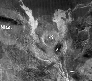
Idem-Kuva is about 230 km across, and is a more complex corona. It lies just north of Gula Mons, and it shows a multi-ringed plan. At the center is a large plateau, about 100 km wide and 600 m high. This looks somewhat like a pancake dome, but it is much bigger. It probably formed by heating and uplift rather than by eruption. On the edge of the central high are two arcuate troughs, and these are bounded in turn by a partial ring of faults. These faults may have once ringed the entire feature, but they seem to be buried on the north by younger plains lavas. Two long, bright lava flows also run north out of the troughs and over the fault ring. These flows are about 150 and 350 km long, and they mark the clearest signs of volcanism in Idem-Kuva.
This image also shows two other features. First, there is a major line of faults running northwards into Idem-Kuva (arrows). These faults are part of a rift zone on Gula Mons, and they may have fed the two lava flows seen in Idem-Kuva. Second, the pale circle in the upper left marks an older volcanic center (Nissaba). This volcano is fairly large but very flat. It is 300 km long by 200 km wide, but it is only about 400 m high. Note how the leftmost flow out of Idem-Kuva curves around its base. This suggests that Nissaba formed before the flow. It may even have formed before Idem-Kuva.
(Image is part of Magellan C1 MIDR 30N351.)
Corona Chain
Many coronas lie in groups or chains. Here, we see one such grouping of 4 or 5 coronas about 200 to 250 km across. It is part of a much longer chain over 4000 km long. The coronas overlap in places, but they are also linked by a number of bright faultlines. These faults are part of a major rift zone, Parga Chasma, that seems to have helped the coronas form. Indeed, the Parga rift has the highest density of coronas to be found on Venus. It also runs into Atla Regio and may have helped to feed the large shields found in that region. Thus, while rifts can bring lavas to the surface, this rift may also lie over a line of deeper mantle melting and uplift.
(Image is part of Magellan C2 MIDR 30S284, centered near 34S, 275E.)
A Simple Arachnoid

This arachnoid lies in the plains northwest of Atla Regio. Like a Corona, it has a clear fault ring and a central (mostly) smooth region. Unlike a Corona, it also has a set of radial ridges which arc away from the fault ring. It is also much smaller than most coronas. In this case, the fault ring is about 95 km across, and most arachnoids are about the same size. In contrast, most coronas are over 200 km across. Still, outside the fault ring, the ridges seem to run 100 to 200 km before merging with other ridge systems.
Most arachnoids show few signs of volcanism. Here, there are a few small shields in the center, but the plains lavas show the clearest signs of volcanism. Note the bright lava flows on the northwest and southeast that seem to come out of the fault ring. Also note how the dark plains arc above the arachnoid, and how they ring the crater in the bottom center (arrows). These all suggest that many large, thin lava flows were erupted as the arachnoid was forming.
(Image is part of Magellan C1 MIDR 45N223, centered near 41N, 214E.)
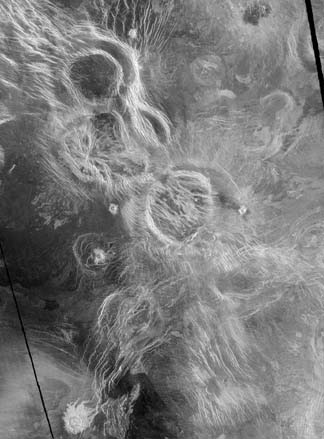
Complex Arachnoids
Arachnoids often lie in faulted plains, and their outer ridges tend to turn into regional patterns. Thus, they often look like spiders on a bright web. Indeed, the name Arachnoid means Rspider-likeS. Here, we see two arachnoids in a faulted plains region (A and B). These features are each about 120 km across, with an outer ring of ridges maybe 150 km wide. Again, there is little sign of volcanism. Only a few bright lava flows are seen in the upper left. A third feature (C) may also be an arachnoid. However, it has only a few radial ridges, and it also shows a caldera-like pattern of nested cliffs. Thus, it is harder to classify. The edge of a larger corona (arrows) also can be seen at the top of the image.
(Image part of Magellan C1 MIDR 45N011, centered near 40N, 19E.)
Simple Nova

Unlike Coronas and Arachnoids, Novas do not have major ring features. Rather, they show a striking starburst of faults and graben. Also, there is often a clear rise at the center of these faults. This example is some 250 km across, and it lies in Themis Regio. There is no clear sign of volcanism, but a few small lava flows may run out from faults in the upper left and upper right. Still, there is a lot of volcanism nearby. Namely, this nova lies within a very long chain of coronas. Indeed, it lies just above the corona chain image in Parga Chasma. Novas mostly occur next to large shields or major corona chains. Thus, they seem to be volcanic. They probably mark an early stage of uplift and faulting that could later become a corona or a large shield volcano.
(Image is part of Magellan C1 MIDR 30S279, centered near 27S, 272E.)
Transitional Form
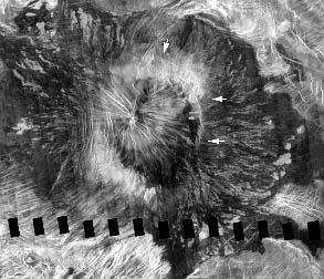
This image may show the future of other novas on Venus. It shows a complex volcano with several clear parts. Its raised center has a clear starburst of nova-like faults. Around this nova is a partial ring of corona-like faults (arrows). Then, outside the corona, is a broad apron of thin bright lava flows. These flows lie on darker lavas which, in turn, clearly bury a much older area of heavily faulted lowlands. In all, the outer lava flows mark the start of a shield volcano some 450 km long by 350 km wide. The central nova itself is about 150 km across. Maybe, in 10 or 50 million years, more flows will finally bury the central nova to make a shield looking like Ushas Mons.
(Image part of Magellan C1 MIDR 15S215, centered at 15S, 215E.)