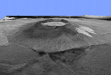
This is a three-dimensional view of Alcedo volcano, on Isabela Island in the Galapagos Islands. This view (covering 75 by 60 km, or 47 by 37 miles) was made by combining a Space Shuttle radar image (SIR-C) and a topographic map. The picture has been stretched in the vertical direction nearly two times so that the volcano appears twice as high as it really is. This helps scientists see changes in the vol cano's shape. On this image you can see the Pacific Ocean at the bottom, and beyond the coastline are the slopes of Alcedo volcano which lead to its large caldera at the top. The bright features on the left are rough lava flows. In a radar image rough areas show up as bright because they reflect a lot of the radar beam; smooth areas (like the sea) are dark because there aren't many reflectors. Radar images like this tell us different information than we get from space photographs; thus the two types of remote sensing information are very useful when used together.

This is another SIR-C radar image showing the southern part of Isla Isabela in the western Galapagos Islands. The image is centered at about 0.5 degree south latitude and 91 degrees west longitude and covers an area of 75 by 60 kilometers (47 by 37 miles).
Alcedo is the volcano with bright (rough) lava flows on its flanks. The other volcano is Sierra Negra. The summit caldera of Alcedo is about 7.3 by 6.1 km wide - its is elliptical, not circular. Sierra Negra's caldera is bigger and more elongated: 9.0 by 7.2 km.
Alcedo's caldera is about 260 m deep, but the bigger caldera is shallower - only 110 m deep.
Source: SIR-C/X-SAR Space radar images of Earth at JPL. Simplified from Jet Propulsion Lab press release P-43899, April 15, 1994.