The most productive volcanic systems on Earth are hidden under an average of 8,500 feet (2,600 m) of water. Beneath the oceans a global system of mid-ocean ridges produces an estimated 75% of the annual output of magma. An estimated 0.7 cubic miles (3 cubic kilometers) of lava is erupted. The magma and lava create the edges of new oceanic plates and supply heat and chemicals to some of the Earth's most unusual and rare ecosystems.
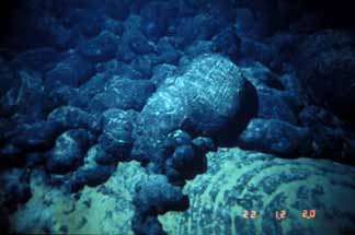
Contact between young pillow lavas erupted in mid-1980s and older lavas with light dusting of sediment.
Hand-held photo from submersible Alvin taken on Cleft segment of southern Juan de Fuca Ridge.
Photo by Bill Chadwick of NOAA and Oregon State University.
Learn more about the alien environment this image was taken in by clicking the buttons below!
If an estimate of 4,000 volcanoes per million square kilometers on the floor of the Pacific Ocean is extrapolated for all the oceans than there are more than a million submarine (underwater) volcanoes. Perhaps as many as 75,000 of these volcanoes rise over half a mile (1 kilometer) above the ocean floor. Technology and hard work by a group of tenacious explorers/geologists have allowed us our first detailed glimpses of submarine volcanoes.
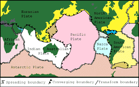
Like continental volcanoes, submarine volcanoes are most common where tectonic plates move towards or away from each other. In the case of divergent plate boundaries, where plates are spreading away from each other, the rate of plate movement plays an important role in determining the type of volcano that forms and the rate of eruptive activity. Submarine volcanoes at convergent plate boundaries (subduction zones) are much like their subaerial ("under air" or continental) counterparts except that the weight of the overlying water modifies their eruption style. Hot spots leave linear "tracks" of seamounts across the ocean basins and build some of Earth's largest volcanoes. Click the drop downs to learn more about these different tectonic settings.
Hot Spot Volcanism
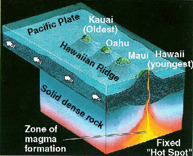
Hot Spot volcanoes are recognized by an age progression from one end of the chain to the other. An active volcano commonly serves as an "anchor" at one end of the chain. The most studied and best well-known hot spot volcanoes and seamounts define the Hawaii-Emperor volcanic chain. The origin and evolution of Hawaiian volcanoes, seamounts, and guyots are described in the Hawaiian Volcano Lessons.
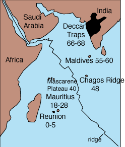
Left: Another noteworthy hot spot track extends from India to the island of Reunion. About 66-68 million years ago present-day India was above the hot spot and great volumes of basaltic lava erupted to produce the Deccan Traps. As the plate moved northeast over the hot spot more volcanic centers formed: the Maldives from 55-60 million years ago, the Chagos Ridge 48 million years ago, the Mascarene Plateau 40 million years ago, and the Mauritus Islands from 18-28 million years ago. The youngest volcanoes, Piton des Neiges and Piton de la Fournaise, formed in the last 5 million years. The summits of these volcanoes make the island of Reunion. Piton des Neiges is extinct. Piton de la Fournaise is one of the most active volcanoes on Earth. Map from Scarth (1994).
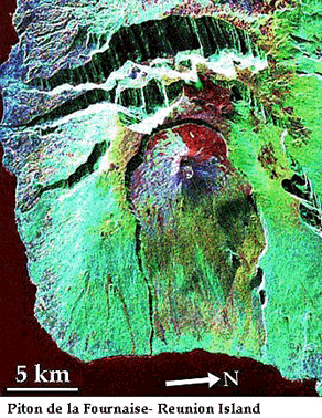
Right: Piton de la Fournaise is also one of the biggest volcanoes on Earth. From the ocean floor it is over 21,600 feet (6,600 m) tall. The base of the volcano has a diameter of 135 miles (220 km)(the base of Mount St. Helens has a diameter of about 9 km). Because of Piton de la Fournaise's great size it is unstable and collapses to form giant landslides like those in Hawaii. This SIR-C image shows the summit of the volcano and the scarps of the giant landslides. Image courtesy of Pete Mouginis-Mark, University of Hawaii.
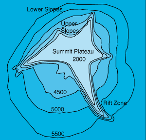 A volcano above a hot spot does not erupt forever. Eventually the movement of the tectonic plate carries the volcano off of its magma supply. The volcano becomes extinct and cools. The plate beneath the volcano (and above the hot spot) also cools. The rocks that make the volcano and plate become more dense. The volcano and the plate gradually subside as they move away from the hot spot. Even giant volcanoes, like Mauna Loa on Hawaii, will eventually disappear into the ocean. As the volcano subsides below sea-level the top is eroded flat by waves. This series of steps leads to a series of evolutionary stages that are well illustrated by the Hawaii-Emperor volcanic chain. This series of steps explains the formation of most guyots, seamounts with flat tops. Other explanations proposed for the formation of guyots include extrusion of lava from ring-shaped conduits. This topographic map of a large guyot is from Vogt and Smoot (1984).
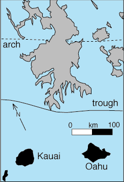
The North Arch volcanic field was recently discovered north of Oahu and is related to the Hawaiian hot spot. The volcanic field is on the Hawaiian Arch. The arch is about 600 feet (200 m) high and formed by the weight of the adjacent islands causing the crust to bend. The volcanic field is made of flood basalts that cover an area of 9,650 square miles (25,000 square km). The flows extend about 60 miles (100 km) north and south away from the arch. The youngest lava range in age from 750,000 to 900,000 years old. The oldest flows are about 2.7 million years old. The field is made of sheetflows and small hills of pillow lava and hyaloclastite Chemically, the lavas are similar to the rejuvenated stage of Hawaiian volcanoes The North Arch volcanic field began erupting when the Waianea and Koolau volcanoes of Oahu were large shields and continue to erupt until Haleakala volcano on Maui was formed. Map from Clague and others (1990).
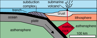
Sections of the "Ring of Fire", a name given to the subduction zones that surround much of the Pacific Ocean, are under water as shown above. Submarine volcanoes at these convergent plate boundaries are much like their counterparts on land. Many of these volcanoes form new islands that last only a short time.
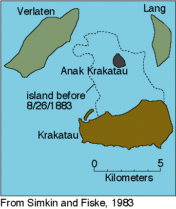
Left: Perhaps the most famous submarine volcano is Krakatau, a submerged caldera located between Java and Sumatra. The 1883 eruption killed at least 36,400 people. Most of these people were killed by tsunami.
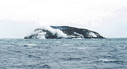
Above: Metis Shoal, a submarine volcano near the Tonga Islands, has erupted nine times since 1851. The summit of the volcano is only a few meters below sea level. The 1979 eruption lasted more than two months, producing a small island that lasted several months before being washed away, and sending rafts of pumice as large as 15x30 miles (25x45 km) floating to the northwest. The most recent eruption began in early June of 1995. As an island grew above sea level a lava dome, about 90 feet feet (30 m) high and 450 feet (150m) is diameter, formed in only a few days. Explosions threw ash to heights of 1500 feet (500 m). A week later the dome was three times larger. The dome stopped growing in late June and may resist erosion for some time. Photo of the dome courtesy Brad Scott, June 28 1995, while on board the Tongan tug Hifofua.
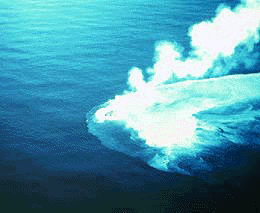
Right: Kavachi, a submarine volcano in the Solomon Islands, has built itself above sea level at least nine times since 1950. The volcano has had 25 known submarine eruptions since 1938. Most of these eruptions include small to moderate explosions. This photograph was taken by John Grover in the early 1960s. Slide courtesy U.S. Geological Survey.
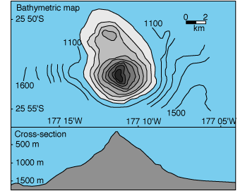
Left: Another very active submarine volcano is Monowai seamount, about midway between the Tonga and Kermadec island groups. The volcano is about 3,000 feet (1,000 m) high and less than 600 feet (200 m) below sea-level. Monowai has erupted at least eight times since 1977. An eruption was suspected in 1944. Most eruptions were detected using acoustics but during the 1977-1979 eruption upwelling and discolored seawater was observed. Monowai erupted most recently in September of 1996 and in April of 1997. Top: Bathymetric map of Monowai seamount. The contour interval is 100 m. Bottom: Profile across Monowai seamount. Vertical exaggeration = 3.7. From Davey (1980).
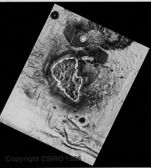 Right: The New World Seamount (top corner of this image),north of Lihir island in Papua New Guinea is 2.5 miles (4 km) wide at its base and has a conical peak. The volcano rises about 1,800 feet (600 m) off the seafloor and has a deep central crater. Sheet and pillow lava flows, volcanic breccias and lag deposits have been photographed at the summit. This seamount is extinct and never rose above sealevel. The subaerial SAR data of Lihir Island was supplied with permission by Lihir Mining Co. Ltd., while the bathymetry data was collected during the R/V SONNE SO-94 Research Cruise (EDISON PROJECT) organized by Freiberg University of Mining & Technology and funded by the German Federal Ministry for Research and Technology (BMFT Grant 03G0094A to P. Herzig). Additional information about the seamount and other seamounts and volcanoes in the area is available on the CSIRO Exploration & Mining (Magmatic-Hydrothermal Cu-Au Group) homepage.
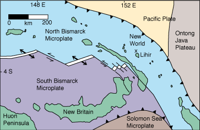
The New World Seamount and the volcanoes that make Lihir Island are associated with the subduction of the Pacific Plate under the North Bismarck microplate. The tectonics in this part of the world is very complicated. A spreading center creates the North and South Bismarck microplates. The Pacific plate is subducted under the North Bismarck Plate. The Solomon Sea microplate is subducted under the South Bismarck microplate. Map from Herzig and others (1994).

Some submarine volcanoes host economic deposits of metals. For example, Kuroko deposits, named for an occurrence in Japan, are hosted in dacite and rhyolite domes and their associated breccias that formed on the basaltic ocean floor. Deposits of zinc, copper, lead, and gold formed when the volcano was active. The volcanoes are later uplifted above sea level or added to the margin of the continent. Modern volcanoes that are forming this type of deposit are found in back-arc basins, areas of rifting behind active volcanic arcs. Understanding modern volcanic environments helps geologist search for more metal deposits. This cross-section of a typical Kuroko deposit is from Sato (1974) and Franklin and others (1981).
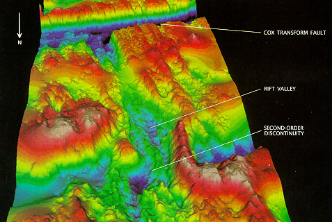
Above: A section of the mid-Atlantic Ridge where the African and South American Plates are created. A rift valley over a mile (2 km) deep marks the axis of the ridge. Depths range from 1900 (pink) to 4200 meters (dark blue). Image used with permission of Ken Macdonald.
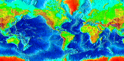
Divergent (or spreading centers) plate boundaries are characterized by features called mid-ocean ridges. Combined, the ridges are nearly 46,000 miles (74,000 km) long. The ridges are home to Earth's highest mountains, deepest canyons, and longest escarpments. The shape of the mid-ocean ridge and the style and rate of volcanism is controlled by the rate the plates move apart.

Mid-ocean ridges are divided into these groups based on their spreading rates (click the buttons to learn more):
Slow: 1-5 cm/yr total opening rate
Medium: 5-10 cm/yr total opening rate
Fast: 10-20 cm/yr total opening rate
Appelgate, B., and Embley, R.W., 1992, Submarine tumuli and inflated tube-fed lava flows on Axial Volcano, Juan de Fuca Ridge: Bulletin of Volcanology, v. 54, p. 447-458.
Baker, E.T., Massoth, G.J., and Feely, R.A., 1987, Cataclysmic hydrothermal venting on the Juan de Fuca Ridge: Nature, v. 329, p. 149-151.
Ballard, R.D., and Tj. H. van Andel, 1977, Morphology and tectonics of the inner rift valley at lat 36.50N on the Mid-Atlantic Ridge: Geological Society of America Bulletin, v. 88, p. 507-530.
Batiza, R., 1989, Petrology and geochemistry of Pacific Spreading Centres in The Geology of North America, v. N, The eastern Pacific Ocean and Hawaii, Geological Society of America, p. 145-159.
Batiza, R., 1989, Seamounts and seamount chains in the eastern Pacific in The Geology of North America, v. N, The eastern Pacific Ocean and Hawaii, Geological Society of America, p. 289-306.
Batiza, R., and Vanko, D., 1983/84, Volcanic development of small oceanic central volcanoes on the flanks of the east Pacific Rise inferred from narrow-beam echo sounders surveys: Marine Geology, v. 54, p. 53-90.
Bougault, H., J.-L. Charlou, Y. Fouquet, H.D. Needham, N. Vaslet, P. Appriou, P. Jean-Baptiste, P.A. Rona, L. Dmitriev and S. Silantiev, Fast and slow spreading ridges: Structure and hydrothermal activity, ultramafic topographic highs, and CH4 output, J. Geophys. Res. B 98, 9643-9651, 1993.
Bridges, N.T., 1995, Submarine analogs to Venusian pancake domes: Geophysical Research Letters, v. 22, p. 2781-2784.
Bryan, W.B., Humphris, S.E., Thompson, B., and Casey, J., 1994, Comparative volcanology of small axial eruptive centers in the MARK area: Journal of Geophysical Research, v. 99, p. 2973-2984.
Cashman, K.V., and Fiske, R.S., 1991, Fallout of pyroclastic debris from submarine volcanic eruptions: Science, v. 253, p. 275-281.
Chadwick, W. W., Jr., and Embley, R. W., 1994, Lava flows from a mid-1980s submarine eruption on the Cleft Segment, Juan de Fuca Ridge: Journal of Geophysical Research, v. 99, p. 4761-4776.
Chadwick, W. W., Jr., Embley, R. W., and Fox, C.G., 1995, SeaBeam depth changes associated with recent lava flows, CoAxial segment, Juan de Fuca Ridge: Evidence for multiple eruptions between 1981-1993: Geophysical Research Letters, v. 22, p. 167-170.
Clague, D.A., Holcomb, R.T., Sinton, J.M., Detrick, R.S., and Torresan, M.R., 1990, Pliocene and Pleistocene alkalic flood basalts on the seafloor north of the Hawaiian Islands: Earth and Planetary Science Letters, v. 98, p. 175-191.
Cone, J., 1994, Life's undersea beginnings: Earth, v. 3, p. 34-41.
Davey, F.J., 1980, The Monowai seamount: an active submarine volcanic centre on the Tonga-Kermadec ridge (Note): New Zealand Journal of Geology and geophysics, v. 23, p. 533.
Dick, H.J.B., Abyssal peridotites, very slow spreading ridges and ocean ridge magmatism, in Magmatism in the Ocean Basins, A.D. Saunders and M.J. Norry (eds.), Geol. Soc. Lond. Spec. Pub. 42, 71-105, 1989.
Embley, R. W., Chadwick, W. W., Jr., Jonasson, I. R., Butterfield, D. A., and Baker, E. T., 1995, Initial results of the rapid response to the 1993 CoAxial event: Relationships between hydrothermal and volcanic processes: Geophysical Research Letters, v. 22, p. 143-146.
Embley, R. W., and Chadwick, W. W., Jr., 1994, Volcanic and hydrothermal processes associated with a recent phase of seafloor spreading at the northern Cleft segment: Juan de Fuca Ridge: Journal of Geophysical Research, v. 99, p. 4741-4760.
Fisher, R.V., Heiken, G., and Hulen, J.B., 1997, Volcanoes: Crucibles of Change: Princeton University Press, Princeton, New Jersey, 317 p.
Fox, C. G., Five years of ground deformation monitoring on Axial Seamount using a bottom pressure recorder, Geophys. Res. Lett., 20, 1859-1862, 1993.
Fox, C.G., W.E. Radford, R.P. Dziak, T.-K. Lau, H. Matasumoto, and A.E. Schreiner, 1995. Acoustic detection of a seafloor spreading episode on the Juan de Fuca Ridge using military hydrophone arrays, Geophysical Research Letters, v. 22, p. 131-134.
Francheteau, J., Juteau, T., and Rangna, R., 1979, Basaltic pillars in collapsed lava pools on the deep ocean floor: Nature, v. 281, p. 209-211.
Francis, P., 1994, Volcanoes a planetary perspective: Oxford University Press, New York, 443 p.
Francis, P.W., and Self, S., 1983, The eruption of Krakatau: Scientific American, v. 249, p. 172-187.
Franklin, J.M., Lydon, J.W., and Sangster, D.F., 1981, Volcanic associated massive sulphide deposits: Economic Geology 75th Anniversary Vol., p. 485-627.
Grindlay, N.R., J.A. Madsen, S. Murphy, C. Rommevaux and J. Sclater, Preliminary results of a high-resolution investigation of an ultra-slow spreading center: Southwest Indian Ridge between 15¡E and 35¡E, Eos, Trans., AGU 76, 272, 1996a.
Halbach, P. and others, 1989, Probable modern analogue of Kuroko-type massive sulphide deposits in the Okinawa trough back-arc basin: Nature, v. 338, p. 496-499.
Haymon, R., D.J. Fornari, K. Von Damm, M. Lilley, M. Perfit, J. Edmond, W.C. Shanks III, Lutz, and others, 1993, Volcanic eruption of the mid-ocean ridge along the East Pacific at 9(45-52'N: I. Direct submersible observation of seafloor phenomena associated with an eruption event in April, 1991, Earth Planet. Sci. Lett., 199, 85-101.
Haymon, R., and others, 1991, Active eruption seen on East Pacific Rise: Eos, v. 72, p. 505-507.
Haymon, R.M., and Macdonald, K.C., 1985, The geology of deep-sea hot springs: American Scientist, v. 73, p. 441-449.
Head, J.W., III, Wilson, L., and Smith, D.K., Mid-ocean ridge eruptive vents: Evidence for dike widths, eruption rates, and evolution of eruptions and axial volcanic ridges: Journal of Geophysical Research, v. 101, p. 28,265-28,280.
Herzig, P., Hannington, M, McInnes, B., Stoffers, P., Villinger, H., Seifert, R, Binns, R., and Liebe, T. 1994. Submarine volcanism and hydrothermal venting studied in Papua New Guinea, EOS, American Geophysical Union, 75 (44), 513-516.
Johnson, H.P., and Embley, R.W., 1990, Axial Seamount: An active ridge axis volcano on the central Juan de Fuca Ridge: Journal of Geophysical Research, v. 95, p. 12,689-12,696.
Lin, J., Purdy, G.M., Schouten, H., Sempere, J.-C., and Zervas, C., 1990, Evidence from gravity data for focused magmatic accretion along the Mid-Atlantic Ridge: Nature, v. 344, p. 627-632.
Livermore, B., 1993. Satellite images turn up the focus on the ocean's floor. Sea Frontiers, v. 39, no. 3, p. 40-45
1996 Loihi Science Team, 1997, Researchers rapidly respond to submarine activity at Loihi volcano, Hawaii: Eos, v. 78, p. 229, 232-233.
Lutz, R.A., R. M. Haymon, 1994. Rebirth of a deep sea vent. National Geographic Magazine 186:114-126.
Lonsdale, P., 1977, Structural geomorphology of a fast-spreading rise crest: The East Pacific Rise near 3 25'S: Marine Geophysics Research, v. 3, p. 251-293.
Macdonald, K.C., 1982, Mid-ocean ridges: fine scale tectonic, volcanic, and hydrothermal processes within the plate boundary zone: Annual Review Earth Planetary, 10, p. 155-190.
Macdonald, K.C. and P.J. Fox, The mid-ocean ridge, Scientific American 262:72-79, 1990.
Macdonald, K.C. and P.J. Fox, The axial summit graben and cross-sectional shape of the East Pacific Rise as indicators of axial magma chambers and recent volcanic eruptions: Earth and Planetary Science Letters, v. 88, p. 119-131.
Macdonald, K.C., R.M. Haymon and A.N. Shor, A 220 km2 recently erupted lava field on the East Pacific Rise near 8¡S, Geology 17: 212-216, 1989.
McInnes, B.I.A., Herzing, P.M. and Hannington, M. 1996. Gold deposition mechanisms in submarine arc volcanoes near Lihir Island, Papua New Guinea. EOS v.77, no. 22, p.118.
McInnes, B.I.A., Binns, R.A., Herzig, P.M., Hannington, M.D. and Binns, R.A. Xenoliths of oceanic fore-arc lithosphere from a submarine lamprophyre cinder cone volcano, Lihir Island Group, Papua New Guinea, in prep. for Earth & Planetary Science Letters.
Mendel, V. and D. Sauter, Seamount volcanism at the super slow spreading Southwest Indian Ridge between 57¡E and 70¡E, Geology, 25(2), 99-102, 1997.
Mendel, V., D. Sauter, L. Parson, and R.J. Vanney, Segmentation and morphotectonic variation along an ultra low spreading centre: the Southwest Indian Ridge (57¡-70¡E), Mar. Geophys. Res., submitted.
Mendel, V., D. Sauter, L. Parson, R.J. Vanney, P. Patriat and M. Munschy, Segmentation of the Southwest Indian Ridge between 57¡E and 70¡E, Eos, Trans., AGU 75, 1995.
Moore, J.G., 1975, Mechanism of formation of pillow lava: American Scientist, v. 63, p. 269-277.
Perfit, M.R., Fornari, D.J., Smith, M.C., Bender, J.F., Langmuir, C.H., and Haymon, R.M., 1994, Small-scale spatial and temporal variations in mid-ocean ridge crest magmatic processes: Geology, v. 22, p. 375-379.
Pluger, W., P. Herzig, K. Becker, G. Deissman, D. Schops, et al., Discovery of hydrothermal fields at the Central Indian Ridge, Marine Mining 9, 73-86, 1990.
Price, R.C., A.K. Kennedy, M. Riggs-Sneeringer and F.A. Frey, Geochemistry of basalts from the Indian Ocean triple junction: Implications for the generation and evolution of Indian Ocean ridge basalts, Earth Plant. Sci. Lett. 78, 379-396, 1986.
Robinson, C.J., R.S. White, M.J. Bickle and T.A. Minshull, Restricted melting under the very slow-spreading Southwest Indian Ridge, in Tectonic, Magmatic, Hydrothermal and Biological Segmentation of Mid-Ocean Ridges, C.J. MacLeod, P.A. Tyler and C.L. Walker (eds.) Geol. Soc. Lond. Spec. Pub. 118, 131-141, 1996.
Rommevaux, C., Ph. Patriat, C. Deplus, M. Munschy, D. Sauter and V. Mendel, Crustal production of an ultra-slow spreading ridge: 3-D gravity study of the Southwest Indian Ridge between the Melville FZ and the triple junction; comparison with the central Mid-Atlantic Ridge, Eos, Trans., AGU 75, 654, 1994.
Rubin, K.H., Macdougall, J.D., and Perfit, M.R., 1994, 210Po-210Pb dating of recent volcanic eruptions on the sea floor: Nature, v. 368, p. 841-844.
Sato, T., 1974, Distribution and geologic setting of the Kuroko deposits: Society. Min. Geol. Japan Special Issue 6, p. 1-9.
Sauter, D. and V. Mendel, Variations of Backscatter Strength along the super slow spreading Southwest Indian Ridge between 57¡-70¡E, Mar. Geology, in press.
Scarth, A., 1994, Volcanoes: Texas A&M Press, 273 p. Scheirer, D.S., and Macdonald, K.C., 1995, Near-axis seamounts on the flanks of the East Pacific Rise, 8N to 17 N: Journal of Geophysical Research, v. 100, p. 2239-2259.
Simkin, T., 1972, Origin of some flat-topped volcanoes and guyots, in Shagam, R., Hargraves, R.B., and others, eds., Studies in earth and space sciences: Geological Society of America Memoir 132, p. 183-193.
Sinton, J.M., and Detrick, R.S., 1992, Mid-ocean ridge magma chambers: Journal of Geophysical Research, v. 97, p. 197-216.
Smith, D.K., and Cann, J.R., 1990, Hundreds of small volcanoes on the median valley floor of the Mid-Atlantic ridge at 24-30N: Nature, v. 348, p. 152-155.
Smith, D.K., and Cann, J.R., 1992, The role of seamount volcanism in crustal construction at the Mid-Atlantic Ridge: Journal of Geophysical Research, v. 97, p. 1645-1658.
Smith, D.K., Humphris, S.E., Tivey, M.A., and Cann, J.R., 1997, Viewing the morphology of the Mid-Atlantic Ridge from a new perspective: Eos, v. 78, p. 265, 269.
Smith, D.K., and others, 1997, Mid-Atlantic Ridge volcanism from deep-towed side-scan sonar images, 25-29N: Journal of Volcanology and Geothermal Resources.
Smith, T.L., and Batiza, R., 1989, New field and laboratory evidence for the origin of hyaloclastite flows on seamount summits: Bulletin of Volcanology, v. 51, p. 96-114.
Solomon, S.C., Just how do ocean ridges vary?: Characteristics and population statistics of ocean ridges, in Drilling the Oceanic Lower Crust and Mantle, JOI/USSAC Workshop Report, Woods Hole Oceanographic Institution Technical Report WHOI-89-39, pp. 73-74, 1989.
Tribble, G.W., 1991, Underwater observations of active lava flows from Kilauea volcano, Hawaii: Geology, v. 19, p. 633-636.
Tunnicliffe, V., 1992. Hydrothermal-vent communities of the deep sea. American Scientist, v. 80, p. 336-349.
Tunnicliffe, V. and C.M.R. Fowler, Influence of sea-floor spreading on the global hydrothermal vent fauna, Nature 379, 531-533, 1996.
Van Dover, C.L., Ecology of Mid-Atlantic Ridge hydrothermal vents, in Hydrothermal vents and processes, L.M. Parson, C.L. Walker and D.R. Dixon (eds.), Geol. Soc. London Spec. Pub. 87, 257-294, 1995.
Vogt, P.R., and Smoot, N.C., 1984, The geisha guyots: Multi-beam bathymetry and morphometric interpreatation: Journal of geophysical Research, v. 89, p. 11085-11107.
Zonenshain, L.P., Kuzmin, M.I., Bogdanov, Y.A., Lisitsin, A.P., and Podrazhansky, A.M., 1989, Geology of the Axial seamount, Juan de Fuca center, Northeastern Pacific, in Sinton, J.M., ed., Evolution of Mid-Ocean Ridges, Geophysical Monograph 57, IUGG volume 8, American Geophysical Union, International Union of Geodesy and Geophysics, p. 53-63.
Some other excellent sources of additional information
The Monterey Bay Aquarium Research Institute is an institute designed create an environment where scientists and engineers could work together to develop new cutting-edge tools for marine research including submarine volcanism.
OSU's /Deepsea Dawn/ Wright has completed oceanographic fieldwork (oftentimes with GIS) in some of the most geologically-active regions on the planet, including the East Pacific Rise, the Mid-Atlantic Ridge, the Juan de Fuca Ridge, the Tonga Trench, volcanoes under the Japan Sea and the Indian Ocean, and, most recently, American Samoa.
Click here to see pictures, obtain GIS resources, and learn more about Deepsea Dawn!.
Everything you ever wanted to know about Submarine Volcanoes, Ridges, and Vents can be found at the USGS Cascades Volcano Observatory (CVO) Submarine Volcano Directory page.
The Vents Program is part of NOAA's Pacific Marine Environmental Laboratory and has excellent photos and movies of ocean floor volcanic features, summaries of their current research, and descriptions of recent submarine eruptions.
The Marine Geoscience Data System has several types of data available on their homepage included excellent maps of ridge segments.
The homepage of the Woods Hole Oceanographic Institute is excellent and includes a gallery of animation and video.
The Ocean Science section of the Smithsonian's Ocean Planet exhibition contains excellent descriptions of recent discoveries about volcanoes and life.
Excellent maps of the general features of the ocean floor are available on the National Geographic Society Online Atlas Explorer.
NASA scientists have created a two-minute animated tour under the Pacific Ocean, based on real data about the sea floor's peaks and valleys. Submerge near Hawaii, run like a submarine to Japan, and finally dive to the ocean's deepest point, between Japan and New Guinea.
Photos of chimneys and life at submarine volcanoes and Deep Sea Movies are available on the Global Observation Information Network ( GOIN ) Project homepage.
New World Seamount is being studied by CSIRO, the Australian federal research organization. An image of the seamount, made from bathymetry data, is available on the CSIRO Exploration & Mining (Magmatic-Hydrothermal Cu-Au Group) homepage.
The 1996 eruption at Loihi seamount is described by the Hawaii Center for Volcanology.
Loihi: Hawaii's Newest Volcano is a short U.S. Geological Survey description of this submarine volcano.
To see a classic bit of oceanic crust that has been thrusted up on a continent (an ophiolite ) visit the Oman Virtual Fieldtrip.