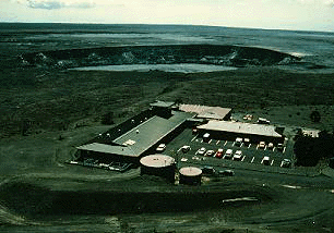
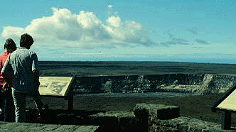
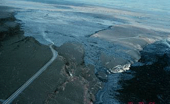
A stop at the Kilauea Visitor Center is a good way to start a visit to the park. The visitor center is open from 7:45 a.m. to 5:00 p.m. daily, year round. Interpretive rangers provide information at the front desk. In addition to exhibits about the park and a sales outlet for the Hawaii Natural History Association, the center contains an auditorium for programs. A 30-minute film is shown on the hour from 9 a.m. to 4 p.m. A schedule for ranger guided walks is usually posted by 10 a.m. On many Tuesday evenings a special program, After Dark in the Park, features experts on the park's geology, biology, and cultural history. This photograph shows the close proximity of the Visitor Center to Kilauea Caldera. Halemaumau pit crater is in the center of the photo and the southeast slope of Mauna Loa volcano is on the horizon.
A common question at the Visitor Center is "Where's the volcano?" The answer is "you are on it" but thick forest hides the view of Kilauea's summit. A short, 5-minute walk to the overlook behind the Volcano House Hotel will convince you that you are on an active volcano. The caldera is also seen along Crater Rim Drive and Crater Rim Trail.
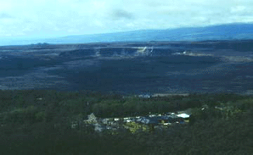
Sulphur Bank is a solfatara. A caldera fault, exposed just north of the Sulphur Bank, serves as a passage way for gases that originate at deeper levels in the volcano. Moderate amounts of sulfur dioxide (SO2) and high amounts of hydrogen sulfide (H2S) are released at Sulphur Bank. In the past this area has been used as a health spa and sauna.
Crystals of native sulfur precipitate on the rocks when the gas reaches the surface. The crystals are fragile (please don't touch). Other minerals, including gypsum, opal, and earthy hematite, form by the weathering of the rock and the precipitation of gases. Gypsum and opal occur as white coatings on the rocks. Hematite is red, like the rust on a car, and stains the rocks in the foreground.
Low amounts of sulfur dioxide (SO2) and hydrogen sulfide (H2S) are released at Steam Vents. An intrusion of magma beneath this area elevated local ground temperatures causing plants with deep root systems to die. Highly fractured rocks and a deep water table prevent hot springs and geysers from forming. The steam at Steaming Bluff is generated under the same conditions as Steam Vents. Kamapuaa, a half-pig half-man demigod, would stand at Steaming Bluff and call to his lover Pele, the Goddess of Fire.
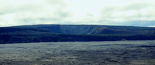
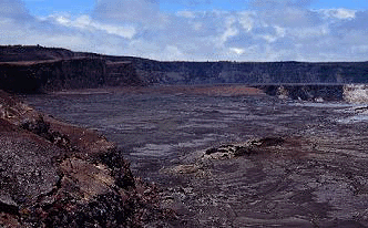
Kilauea Overlook, about 2 miles (3 km) east of the Visitor Center, provides an excellent view of Kilauea Caldera. On the horizon is the Ai-laau shield. This vent was active about 350-500 years ago and sent lava all the way to the ocean. The path to the overlook is on ash from the 1790 explosive eruption of Kilauea. The caldera probably formed during this eruption. Collapse to produce the caldera is the result of magma withdraw from the chamber 3-6 miles (2-4 km) below the summit. Kilauea Iki is in the center of the photograph. Puu Puai cinder cone is on the rim (just right) of Kilauea Iki.
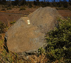
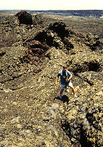
In addition to ash, large blocks up to 6 feet (1.8 m) in diameter are on the rim. These blocks were torn from the walls of the vent and thrown to their present location. The tephra deposit from the 1790 eruption is only a few feet thick on this side of the caldera. The scale on the block is about 5 inches (12 cm) long.
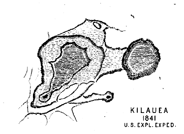
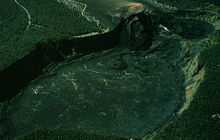
Kilauea Caldera has changed dramatically in the last 150 years. This map was made by U.S. Exploring Expedition. Notice the presence of a large ledge within the caldera. The expedition's geologists, James D. Dana, made significant contributions to the understanding of Hawaiian volcanoes and is considered by some as America's first volcanologist. Prior to 1924, a large lava lake covered most of the floor of the caldera. Since the 1924 eruption, lava has been restricted to Halemaumau or fissures in the summit area and, overall, the caldera is being filled gradually by lava.
The Hawaiian Volcano Observatory was established in 1912 by Dr. Thomas Jaggar of the Massachusetts Institute of Technology. The original observatory was at the present location of the Volcano House. The observatory was moved to Uwekahuna Bluff, the highest point on the caldera rim, in 1916, when the national park was created. The observatory has been managed by the Hawaiian Volcano Research Association, the U.S. Weather Bureau, the U.S. Geological Survey, and the National Park Service. Halemaumau pit crater is in the background. Photograph by J.D. Griggs, U.S. Geological Survey, October 23, 1986.
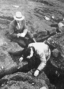
Jaggar believed that loss of life and property from volcanic eruptions could be minimized by better understanding the ways that volcanoes work. He developed many methods to study Hawaiian volcanoes, including the use of seismographs to study the size, number, and distribution of earthquakes associated with the volcanoes. This photograph shows Jaggar taking notes as a coworker measures cracks on the rim of Halemaumau. Photograph from The Volcano Letter, No. 434, 1936.
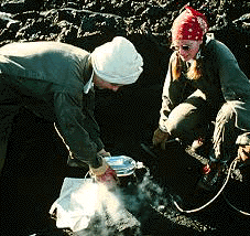
Jaggar's work is continued today by geologists of the U.S. Geological Survey. Using seismology, ground deformation, geology, and geochemistry, these scientists study all aspects of the volcano. What they learn is used to protect citizens and property near more dangerous volcanoes around the world. This photograph shows geologists cooling a lava sample they collected through a skylight. The chemistry of the sample can indicate changes in the eruption. Photograph by J.D. Griggs, U.S. Geological Survey, December 5, 1990.
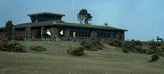
The Jaggar Museum contains numerous exhibits that explain the history and behavior of Hawaiian volcanoes. The museum and a sales outlet for the Hawaii Natural History Association are open from 8:30 a.m. to 5:00 p.m. Nene, the state bird of Hawaii, frequent the museum parking lot. Please follow park rules to protect these birds.

Seismometers and a tiltmeter on display in the museum provide real-time data about the volcanoes. This photograph shows the record for a tilt meter. Rapid increases in tilt can indicate that magma is accumulating at shallow levels within the volcano and is often a precursor to an eruption. Rapid decreases in tilt can indicate that magma is draining at shallow leaves within the volcano and moving into a rift zone. Movement of magma into a rift zone is often a precursor to a flank eruption. The tilt record in the above photograph is flat. It indicates that magma is moving from deep beneath the volcano, through the shallow magma chamber beneath the summit, and out to the eruption site on the east rift with no interruption. Recent flow maps and copies of VolcanoWatch, a weekly newspaper article about the volcanoes, are also on display.
Most of the volcanic features at the summit of Kilauea can be seen from the overlook at Jaggar Museum. Crater Rim Drive and Crater Rim Trail provide access to most of these features. Exhibits at the overlook explain how the caldera formed and the basics of how the volcano works.
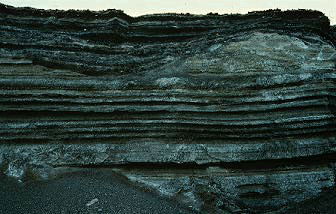
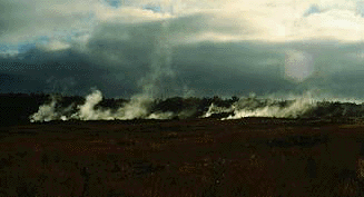
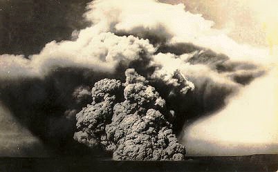
About 200 years ago, as Kilauea caldera formed, large volumes of ash erupted at the summit and lava erupted on the lower east rift zone. The ash blankets the summit of Kilauea volcano (photograph by J.D. Griggs, U.S. Geological Survey, August 14, 1986).
Hawaiian eruptions are characteristically very gentle. However, under certain conditions, they can be violent. The following quote describes the events at the summit of Kilauea during the 1790 eruption as witnessed by Hawaiian warriors.
"The company in advance had not preceded far before the ground began to shake and rock beneath their feet and it became impossible to stand. Soon a dense cloud of darkness was seen to rise out of the crater, and almost at the same instant the electrical effect upon the air was so great that the thunder began to roar in the heavens and the lightening to flash. It continued to ascend and spread abroad until the whole region was enveloped and the light of day was entirely excluded. The darkness was the more terrific, being made visible by an awful glare from streams of red and blue light variously combined that issued from the pit below, and being lit up at intervals by the intense flashings of lightening from above. Soon followed an immense volume of sand and cinders which were thrown in high heaven and came down in a destructive shower for many miles around. Some few persons of the forward company were burned to death by the sand and cinders and others were seriously injured. All experienced a suffocating sensation upon the lungs and hastened on with all possible speed."
Written by Kamakau and reported in Westervelt's Hawaiian Legends of Volcanoes.
The eruption also killed eighty Hawaiian warriors about six miles (10 km) southwest of the summit. The warriors were returning to the Kau district to defend it from an attack by Kamehameha. Some viewed the eruption, which reduced the strength of a rival chiefs army, as a demonstration of Pele's favor of Kamehameha. Kamehameha ultimately united and ruled all of the Hawaiian Islands.
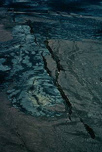
The southwest rift zone is one of two rift zones on Kilauea volcano. The rifts are weak areas in the volcano where it is being pulled apart. Magma, a few miles below the surface, moves from the summit down and through the rift. It pushes sideways against the volcano, causing it to spread. The brittle rocks above this intrusion cannot stretch. Instead, they crack. The cracks on the southwest rift zone are associated with a magnitude 7.9 earthquake that occurred in 1868. Shortly after the earthquake, a batch of magma left Kilauea's summit and traveled down the rift zone. As the magma moved down the rift it caused the cracks we see at the surface today. Crater Rim Drive is near the top of the photo. Photograph by J.D. Griggs, U.S. Geological Survey, March 4, 1985.
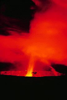
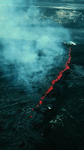
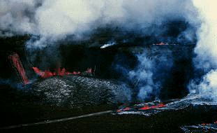
Sometimes the magma in the rift rises to the surface to generate an eruption. This happened twice in the early 1970s on the upper southwest rift zone. In September of 1971, an eruption began on the floor of the caldera and migrated into the southwest rift zone. It was the first eruption on this rift since 1921. Although inflation of the summit of the volcano and earthquake activity had increased in previous weeks, harmonic tremor, an indication that magma was moving, began only 50 minutes before the eruption. The geologists living in the park were altered by an alarm that was triggered by earthquakes. They managed to get to the observatory in only eight minutes and witness the onset of the eruption. The eruption lasted five days producing lava fountains, cascades of lava into Halemaumau, flows which crossed the road, and new cracks in the rift zone. History repeated itself in September of 1974. Again, an eruption began on the floor of the caldera and migrated into the southwest rift zone. The eruption lasted four days and covered much of the lava erupted in 1971. This photograph, taken from the rim of the caldera, shows the fissure on the caldera floor. Halemaumau is on the top, right corner of the photo. Photograph by J.P. Lockwood, U.S. Geological Survey, September 19, 1974.
The vents for the September 1974 eruption can still be seen from the rim of the caldera. Compare this photo to the one above. Crater Rim Drive crosses the main fault that defines the southwest edge of Kilauea caldera. The fault is draped by the 1790 ash deposit, indicating that the caldera was already in the process of forming when the ash began to erupt.
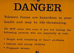
A walk out to the overlook of Halemaumau Crater convinces even the strongest skeptics that Kilauea is an active volcano. The gases released at the crater make an immediate impression on one's sense of smell and taste. The high amounts of sulfur dioxide (SO2) are hazardous to young children, pregnant women, and the elderly and these people should avoid the area.
Adjacent to the trail are blocks thrown from Halemaumau during an explosive eruption in 1924.
The 1924 phreatic eruption was caused by a rapid drop in the level of a long-lived lava lake within Halemaumau that allowed ground water to come in contact with hot rock. After this eruption the crater was 1,345 feet (410 m) deep. Photograph from a postcard circa 1924.
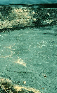
Since 1924, Halemaumau has been gradually filling with lava from numerous short-lived eruptions. The longest of these eruptions lasted about eight month from 1967-1968. Photograph by R.S. Fiske, U.S. Geological Survey, December 1967.
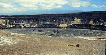
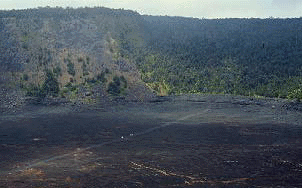
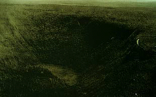
Halemaumau is about 280 feet (85 m) deep and 3,000 feet (915 m) across. The prominent ledge about half-way up the crater wall marks the high stand of the 1967-1968 lava lake. The floor of the crater collapsed in 1971. The lava on the floor of the crater is from the 1974 eruption that was erupted on the southwest rift zone just outside of Halemaumau. Mauna Loa volcano is in the background.
Because Halemaumau is so big, it is difficult to get a feel for its size. A helicopter in this photo serves as a familiar reference (if you can find it).
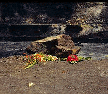
Halemaumau is also the home of Pele, the Hawaiian Goddess of Fire, making it a sacred place to Hawaiians. It is not unusual to see offerings to Pele, such as sacred Hawaiian plants, left on the rim of the crater.
A short walk beyond the Halemaumau Overlook is a spatter rampart produced by an eruption in April 1982.
The April 1982 eruption lasted only 19 hours. It was preceded by rapid inflation of the summit of the Kilauea and a swarm of small earthquakes that lasted 3 hours. Photography by J. P. Lockwood, U.S. Geological Survey, April 30, 1982.
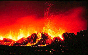
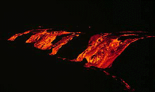
Lava erupted from a fissure and produced a curtain of fire 15-30 feet (5-10 m) high. Photography by J. P. Lockwood, U.S. Geological Survey, April, 1982.
Crater Rim Drive continues east from the Halemaumau parking area and gradually climbs the southeast rim of Kilauea Caldera.
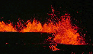
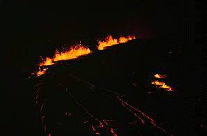
The second eruption in 1982 began on the evening of September 25 and lasted only 15 hours. Curtains of fire developed above the fissures. This was the most recent summit eruption of Kilauea volcano. Photograph by J.D. Griggs, U.S. Geological Survey, September 25, 1982.
Two fissures formed in the southern part of Kilauea caldera (top of photo, just left of center) and sent lava flows to the northwest and south (towards the center of the photo). Photograph by Norm Banks, U.S. Geological Survey, September 26, 1982.
The northwest flow crossed Crater Rim Drive and spilled into the caldera. Volcanologists on duty during the eruption reported feeling several dozen earthquakes. Photograph by Ted Wolf, U.S. Geological Survey, September 26, 1982.
Keanakakoi pit crater is 115 feet (35 m) deep and about 1,500 feet (450 m) wide. Keanakakoi means "place of the adze" and is named for a dense layer of basalt that the Hawaiians used for making tools. Lavas from an eruption in 1877 buried this layer of rock. The lava on the floor of the crater is from the 1974 eruption.
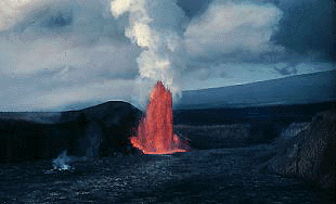
In August of 1971, Kilauea erupted from fissures in and along the southeast part of the caldera. Although this eruption was only 10 hours long, it was very spectacular, generating fountains up to 250 feet (75 m) high, lava cascades, and lava flows that covered nearly one-fifth of the caldera floor. Lava is moving away from the fissures to the north (top left corner). Photograph by D.W. Peterson, U.S. Geological Survey, August 14, 1971.
Kilauea erupted again in July of 1974 from fissures in the Keanakakoi area and the south part of the caldera. Prior to the eruption, tilt at the summit decreased rapidly and tremor increased sharply. Lava covered the floors of Keanakakoi and Lua Manu craters. Notice the three erupting fissures. Crater Rim Drive is along the bottom of the photo. Photograph courtesy of the U.S. Geological Survey, July 19, 1974.
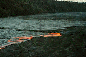
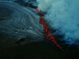
Lava from the fissures cascaded over the rim of the caldera and nearly buried all of the flows from the August 1971 eruption. The lava moved north in a natural moat that rings the caldera. The moat is a result of the more frequent eruptions near Halemaumau that built that area higher. The eruption lasted about three days. Photograph by D.W. Peterson, U.S. Geological Survey, July 20, 1974.
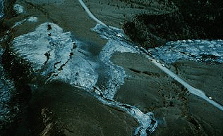
Three spectacular spatter ramparts are near Keanakakoi crater. They can be visited along the trail that leads to the caldera overlook. A lava spillway (bottom center of the photo) drained lava onto the caldera floor. Photograph by E. Rodriguez, U.S. Geological Survey, August 1, 1974.
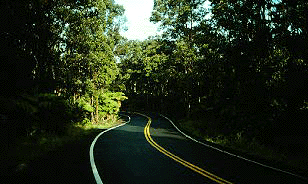
As Crater Rim Drive continues to the east it enters the rain forest. This side of the caldera receives about 100 inches (250 cm) of rain per year.
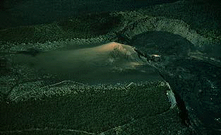
Puu Puai is a cinder cone that formed during the 1959 eruption at Kilauea Iki Crater. Puu Puai means "gushing hill." Gas leaving the magma propelled incandescent cinder and ash as high as 1,900 feet (580 m) above the vent. Tradewinds blew the cinder and ash to the southwest, where it accumulated to form the cinder cone. With increasing distance to the southwest, the cinder and ash deposit gets thinner and the size of the volcanic particles gets smaller. Puu Puai parking area (lower right corner) is on the rim of Kilauea Iki crater. Devastation Trail skirts the tree line. Kilauea Caldera is on the top left. Photograph by J.D. Griggs, U.S. Geological Survey.
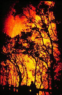
This was the view of the lava fountain from near the present day Puu Puai parking lot. Photograph courtesy of the National Park Service, December 1974.
The overlook at Puu Puai provides an excellent view of the Kilauea Iki pit crater and the Kilauea Iki trail. It is also one of the windiest places in the park. Note the people on the Kilauea Iki Trail for scale. Kilauea Overlook is on the opposite rim.
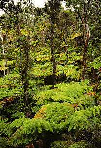
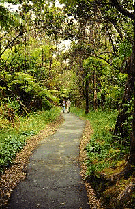
The lava tube formed about 350-500 years ago. At that time a large vent, called the Ai-laau shield, was erupting on the east side of Kilauea's summit. Lava from this vent buried the entire north flank of Kilauea, all the way to the ocean. After the eruption ceased, the summit of the vent collapsed to produce the Kilauea Iki pit crater. Additional collapse adjacent to the Kilauea Iki pit crater produced two other small craters. Access to the lava tube is through one of these small pit crater. The trail descends along the wall of the crater then across its floor. The 20-minute walk at Thurston Lava Tube will give you a close-up look at a Hawaiian rainforest and the lava tube. Be careful, the trail can be slippery when wet. This photograph shows the lush vegetation inside the small pit crater.
When the eruption stopped the lava drained from the tube. The trail within the tube is 400 feet (120 m) long. The tube extends beyond the main trail before pinching off (permission to visit this part of the tube must be granted at park headquarters prior to entry). The tube is named for Lorrin Thurston, a newspaper publisher that played an instrumental role in creating the park. Thurston lava tube is also called by its Hawaiian name, Nahuku, which refers to the small protuberances on the walls of the tube. Photograph by T.J. Takahashi, U.S. Geological Survey, September, 7, 1984.
The surrounding forest is one of the parks's Special Ecological Areas. Aggressive alien species are changing ecosystems in much of Hawaii. To protect native habitats within the park, rangers are removing alien species and building fences to keep out feral pigs. Pigs disturb the native plants, which helps to introduce alien plant species, and spread disease, like avian malaria.
The Kilauea Iki pit crater formed near the top of the Ai-laau shield, a vent for Kilauea volcano about 350-500 years ago. The Ai-laau eruption was probably fed by a shallow magma chamber a few miles below the surface. Magma within this chamber either erupted on the surface or drained down into deeper levels within the volcano. After the eruption ceased, the chamber was no longer full and exerted less pressure on the surrounding rocks. The weight of the overlying rocks was greater that the upward pressure in the chamber. The rocks above the chamber collapsed, filling the open space within the chamber and causing the surface to collapse, making Kilauea Iki crater. The collapsed probably occurred between 350 and 200 years ago. Photograph J.D. Griggs, U.S. Geological Survey.
Prior to the 1959 eruption, Kilauea Iki was nearly 600 feet deep and heavily forested. A section of Crater Rim Drive can be seen on the right. Photograph courtesy U.S. Geological Survey, 1923.
The Kilauea Iki eruption began on November 14, 1959 and last 36 days. During that time there were 17 episodes of lava fountaining. The eruption filled the crater with 390 feet (120 m) of new lava and constructed the Puu Puai cinder cone. Many long-time lava watchers considered this the best eruption they have seen.
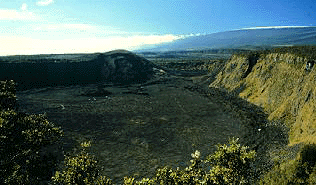
The overlook of Kilauea Iki pit crater is one of the most spectacular views in the park. Kilauea Iki is in the foreground. Puu Puai cinder cone is on the opposite rim of the crater. Byron's Ledge is a horst between Kilauea Iki pit crater and Kilauea caldera. A keen eye can find Halemaumau. snow-capped Mauna Loa forms the skyline.