Northern Chile
Synonyms: None
Location: 17º43'S; 69º46'W
Type: Simple
Summit Elevation: 5980 m
Edifice Height: 1700 m
Status: Dormant
Structure and Evolution
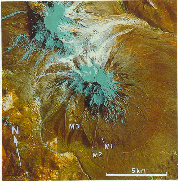
Bounded on its western flanks by the Peru-Chile frontier, Tacora (T) is the northernmost volcano in Chile and is the youngest and most southerly of a twin system with Co. Chupiquina. It was catalogued by Casertano (1963) as one of the few active volcanoes in north Chile and is therefore included here (Figures 9.1; 9.2). Although extensively glaciated, Tacora retains a broad based symmetrical form rising from a base level of about 4,300 m to a summit elevation of 5,980 m. Above ~5,500 m the edifice is covered by snow, preventing detailed observations of the summit region, but Casertano (1963) reported that a crater is situated about 300 m below the summit on the NW side. Several sets of moraines are well developed on the lower flanks of the volcano, particularly on the southern and eastern flanks. The earliest of these (M1) appears to have been left by a continuous sheet of ice extending to below 4,500 m , and terminating roughly parallel with the present Uchusuma Canal. On the southwest flank of the volcano two prominent glacial valleys with prominent lateral moraines cut these and terminate at about 4,400 m. They may be related to the ~11,000 yr BP glacial advance (M2). A third set of terminal moraines is developed within a prominent cirque like feature at about 4,900 m (M3) and may date to the "Little Ice age" about 600 yr B.P. There is no evidence on the satellite images of any Holocene activity, however young lava flows have been described as overlying glacial valleys.
Current Activity
Casertano (1963) reported that Tacora was in a 'solfatara' stage with active low temperature fumaroles on the E side of the crater. As the image reveals, however, the volcano has been heavily dissected, so that the reported fumarolic activity may be unreliable. Fresh hydrothermally altered material washing down from the summit and numerous sulphur mines located on the saddle between Tacora and Chupiquina confirm that the volcano has experienced extensive fumarolic alteration and acid leaching. Hot springs on the eastern side of the edifice may be a manifestation of the continuing active hydrothermal system of the volcano.
Hazard
No information.
Geochemistry
Douglas (1914) reported that the lavas from Tacora and Chupiquina are andesites. Wörner et al., (unpub. data, 1990) describe olivine-phyric basaltic andesites and mafic amphibole rich andesites. 7 analysed samples show a range of SiO2 from 56.5 to 62%.
References
Casertano,L., 1963. Catalogue of the active volcanoes of the world; Part XV, Chilean continent I.A.V.C.E.I. Naples, Italy, 55pp.
Douglas, J.A., 1914. Geological section through the Andes of Peru and Bolivia. I. From the coast of Arica in the north of Chile to La Paz and the Bolivian Yungas. Quart. Jour. Geol. Soc. London V.70, p1 - 53