Last Updated: 10 July 2000

|
Shasta from the southwest. Shasta, 40 miles (65 km) south of the California-Oregon border is the second highest (14,161 feet, 4,317 m)mountain in the Cascade Range. The volcano is composed of four overlapping andesiteeruptive centers all visible in the photograph. The oldest center is the Sargeants Ridge cone, located on the strongly eroded lower slopes of Shasta, was active about 450,000 years ago. Misery Hill, on the northwest flank of the Sargeants Ridge cone, was active between 15,000 and 20,000 years ago. Shastina, the prominent cone on the west flank of Shasta, was active around 9,200 years ago. The Hotlum cone is the youngest eruptive center and forms Shasta's summit and the north and northeast flanks. Hotlum cone was active only a few centuries ago. Photo by R. Forrest Hopson.

|
View to the east of alpenglow on Shasta. Diller Canyon, the prominent canyon on Shastina, funneled a large pyroclastic flow about 9,230 years ago. This pyroclastic flow covers the ground now occupied by the town of Weed. Photo by R. Forrest Hopson.

|
Shastina (12,330 feet, 3,759 m) from high on Shasta. Shastina is made up of mostly andesite flows and several dacite summit domes. Head of Whitney Glacier in foreground. View is to the northwest. Photo by R. Forrest Hopson.

|
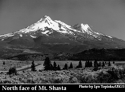
Shasta from the north. The hummocks in the foreground are debris avalanche deposits from Shasta that are between 300,000 and 380,000 years old. These deposits cover an area of 260 square miles (675 square km) in the Shasta Valley and occur over 45 miles (70 km) from the volcano. Estimated volume of the deposits is 10 cubic miles (45 cubic km). The hills rise up to about 300 feet (100 m). This was the most recent debris avalanche at Shasta. Photo by R. Forrest Hopson.
 |
Aerial view of blocky basaltic andesite lava flow north of Shasta. This four mile (six km) long flow erupted from Shastina. The flow is about 350 feet (110 m) thick at its front and less than 9700 years old. Highway 97 is at the bottom of the photo. Photo courtesy of U.S. Geological Survey (Figure 5 from Miller,1980).
 |
Aerial view to the north-northwest to Black Butte. Black Butte is made of four overlapping dacite lava domes that erupted about 9,500 years ago. Interstate Highway 5 is just to the left of the butte. Photo courtesy of U.S. Geological Survey (Figure 3 from Miller,1980).
 |
Over the last 10,000 years, Shasta has erupted on average once every 800 years. During the 3,500 years the volcano has erupted about once every 300 years. The most recent eruption may have occurred in 1786 A.D.
 |
Shasta. Copyrighted photograph by Steve O'Meara of Volcano Watch International.
More images of Shasta on Volcano World.
Visit the Casacade Volcano Observatory homepage for more information on the eruptive history and volcanic hazards of Shasta.
The Casacade Volcano Observatory homepage also offers more photos of Shasta.
For historical perspectives of the volcano visit the Mount Shasta Collection homepage.
If you are thinking of climbing Shasta you might want to read this story.
Sources of Information:
Crandell, D.R., 1989, Gigantic debris avalanche of Pliestocene age from ancestral Mount Shasta volcano, California, and debris-avalanche hazard zonation: U.S. Geological Survey Bulletin.
Crandell, D.R., and Nichols, D.R., 1987, Volcanic hazards at Mount Shasta, California: U.S. Geological Survey pamphlet, 21 p.
Crandell, D.R., Miller, C.D., Glicken, H.X., Christiansen, R.L., and Newhall, C.G., 1984, Catastrophic debris avalanche from ancestral Mount Shasta volcano, California: Geology, v. 12, p. 143-146.
Miller, C. Dan, 1980, Potential hazards from future eruptions in the vicinity of Mount Shasta volcano, California: U.S. Geological Survey Bulletin 1503, 43 p.
Wood, C.A., and Kienle, J., 1993, Volcanoes of North America: Cambridge University Press, New York, 354 p.