 Space Shuttle photo STS058-0019-0005. |
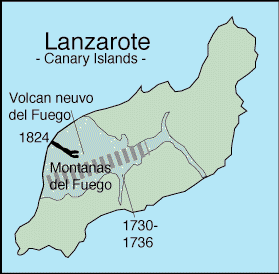 Recent volcanic features of the island of Lanzarote,, from Neumann van Padang (1967). Thick gray dashed line shows the location of a rift zone proposed by Carracedo (1994). |
Lanzarote, a shield volcano made of prominent fissure vents, is ~20 million years old. There are four main calderas and numerous cones and fissures. Basalts erupted in 1730-1736 and 1824 cover about one fourth of the surface of the island. The vents for the 1730-1736 eruption are near Montanas del Fuego. The 1824 eruption lasted about three months and was focused at the Nuevo del Fuego vent. The north end of the Island of Fuerteventura can be seen near the bottom of the photo. Did you notice that the shape of the island differs on the space photo compared to the map? How can that be? Which one is wrong? The answer is that both views are correct! The map shows the island as it would be seen looking directly down on it, with no distortion. The space photo was taken through the window of the Space Shuttle when the island was off to the side. The oblique view made the island look shorter.
Sources of Information:
Carracedo, J.C., 1994, The Canary Islands: an example of structural control on the growth of large oceanic-island volcanoes. J. Volcanology and Geothermal Research, v. 60, p. 225-241.
Neumann van Padang, M., Richards, A.F., Machado, F., Bravo, T., Baker, E., Le Maitre, W., 1967, Part XXI, Atlantic Ocean: Catalogue of the active volcanoes of the world, International Association of Volcanology, Rome, Italy, 128 p.
Simkin, T., and Siebert, L., 1994, Volcanoes of the World: Geoscience Press, Tucson, Arizona, 349 p.