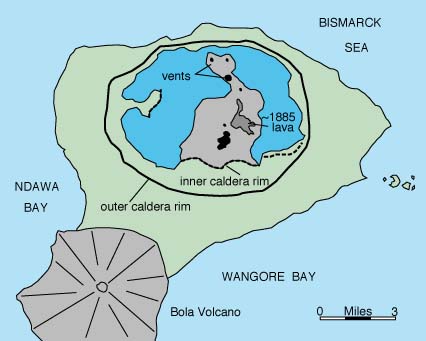
Dakataua caldera is 10 by 13 km and has a volume of 75 cubic km. The most recent episode of caldera collapse was probably about 1,150 years ago. Mount Makalia, an andesite volcano, and other volcanoes that have erupted along the outer caldera rim partially fill the caldera. The freshwater lake is at least 120 m deep. The most recent eruption was at Mount Makalia in 1890. The eruption produced three cinder cones and lava flows.
Simplified map of Dakataua caldera from Newhall and Dzurisin (1988).
 |
Space Shuttle photo STS028-0090-0084 taken on July 13, 1989. The photo looks south along the Talasea Peninsula. Dakataua caldera forms the north end of the peninsula. The peninsula is about 50 km long. |
Johnson, R.W., 1976, Late Cainozoic volcanism and plate tectonics at the southern margin of the Bismarck Sea, Papua New Guinea, in Johnson, R.W., ed., 1976, Volcanism in Australia: Amsterdam, Elsevier, p. 101-116.
Lowder, G.G., and Carmichael, I.S.E., 1970, The volcanoes and caldera of Talasea, New Britain: geology and petrology: Geol. Soc. America Bull., v. 81, p. 17-38.
Newhall, C.G., and Dzurisin, D., 1988, Historical unrest at large calderas of the world: U.S. Geological Survey Bulletin 1855, p. 210-213.
Simkin, T., and Siebert, L., 1994, Volcanoes of the World: Geoscience Press, Tucson, Arizona, 349 p.