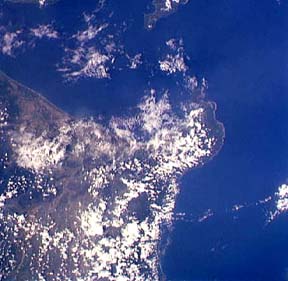
Space Shuttle photo STS059-0095-0080 photo taken on April 11, 1994. View is to the northeast.
Camiguin Island is in the top right corner. Fuga Island is in the bottom left corner.
Camiguin de Babuyanes is a stratovolcano that forms the southwestern end of Camiguin Island. Most of the volcano is covered by forest.
There has been a single historic eruption on the southwest flank prior to 1857. The eruption was phreatic and moderate in size (VEI=2).

Space Shuttle photo STS059-0212-0089 taken on April 13, 1994. View is to the northwest.
Mt. Cagua (a Holocene stratovolcano with an eruption suspected in 1860) is hidden by the clouds that obscure the peninsula near the center of the photo.
Camiguin de Babuyanes is the island at the top of the photo.
Sources of Information:
Neumann van Padang, M., 1953, Philippine Islands and Cochin China. Catalogue of the Active Volcanoes of the World, International Association of Volcanology, 2, Rome, Italy, 49 p.
Simkin, T., and Siebert, L., 1994, Volcanoes of the World: Geoscience Press, Tucson, Arizona, 349 p.